 Image
Image
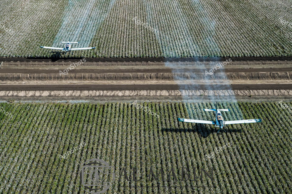
Aerial agricultural symphony: twin agricultural aircraft glide precisely over vast cotton fields, executing a critical defoliation mission. The expansive plantation stretches in meticulously ordered rows, transitioning through subtle green and silvery-white hues, revealing cotton plants at different stages of maturation. Specialized agricultural planes emit controlled plumes of silvery spray, preparing the cotton crop for efficient mechanical harvesting by removing leaves and enabling clean, streamlined picking. The geometric precision of the landscape - with its rigorous linear patterns of cultivated earth and verdant crop rows - speaks to the sophisticated, scientific approach of modern Australian cotton farming. Soft morning light casts gentle shadows, highlighting the intricate choreography of aerial agricultural technology traversing the immense, carefully managed agricultural landscape of regional Queensland. This image captures the technological poetry of contemporary broad-acre farming, where precision, efficiency, and environmental management converge in a breathtaking aerial ballet.
 Image
Image
Agricultural Aviation: Cotton Defoliation in Queensland Twin agricultural aircraft glide low over a precisely planted cotton field, releasing billowing plumes of chemical spray that drift across the meticulously gridded landscape. These specialized aerial applicators execute a critical pre-harvest technique, systematically defoliating the cotton crop to prepare for mechanical harvesting. The geometric rows of green-grey plants stretch to the horizon, creating a structured canvas punctuated by the fluid movement of the planes. Soft blue-grey smoke trails mark their precise passage, demonstrating the technical precision of modern agricultural practices in Queensland's expansive cotton-growing regions. The aerial perspective reveals the immense scale of contemporary farming, where technology and scientific methodology transform agricultural production. These purpose-built aircraft represent the pinnacle of efficient crop management, enabling farmers to optimize yield and quality through strategic intervention.
 Image
Image
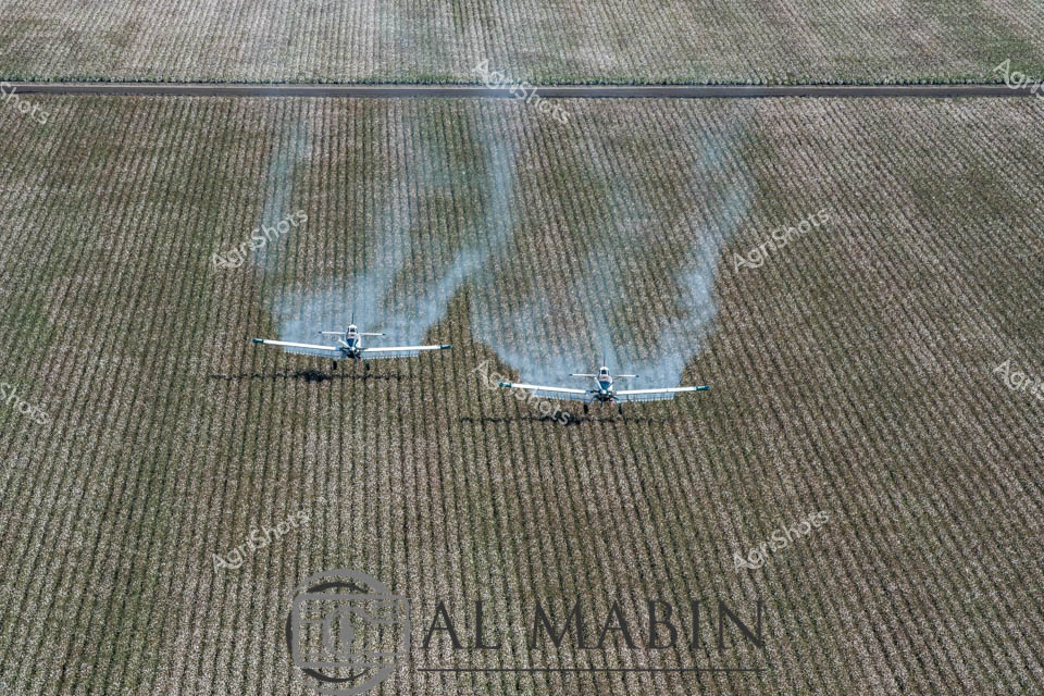
Precision agricultural aviation transforms the vast cotton fields of Queensland, with two specialized agricultural aircraft gliding low over meticulously planted rows of defoliated cotton. Blue and white planes navigate with surgical accuracy, casting crisp shadows across the silvery-green landscape, preparing the crop for imminent harvest. The uniform grid of the cotton field stretches to the horizon, each row carefully cultivated to maximize yield and efficiency. These agricultural aircraft represent cutting-edge farming technology, using specialized spray systems to apply defoliant chemicals that will enable mechanical harvesting by removing leaves and preparing the cotton bolls for collection. The metallic-toned planes move in synchronized formation, their wings reflecting the bright Australian sunlight, embodying the sophisticated intersection of aviation and agricultural science. Every element of this scene speaks to modern agricultural practices - methodical, technological, and designed to extract maximum productivity from the rich Queensland farmlands.
 Image
Image
Agricultural aerial symphony: a precision agricultural aircraft glides low over an immaculate cotton field, its wings perfectly aligned with the meticulously planted rows stretching across the landscape. The monochromatic green and grey tones of the ripening cotton crop create a mesmerizing geometric pattern, revealing the disciplined agricultural engineering of modern farming. This agricultural aircraft is executing a critical defoliation mission, preparing the cotton field for harvest by systematically spraying chemicals that will trigger leaf drop and facilitate efficient mechanical harvesting. The crisp early morning light reveals the intricate texture of the crop, with perfectly uniform rows creating a rhythmic visual pattern that speaks to the scientific precision of contemporary agricultural practice. The aircraft, a specialized agricultural workhorse, sits low against the horizon, its shadow cast precisely between the crop rows, demonstrating the calculated navigation required in precision agriculture. This image captures the sophisticated technological intersection of aviation and farming, highlighting Queensland's advanced agricultural techniques and the remarkable choreography of modern crop management. The scene embodies the strategic beauty of large-scale agricultural production - a testament to human ingenuity and technological mastery over complex environmental systems.
 Image
Image
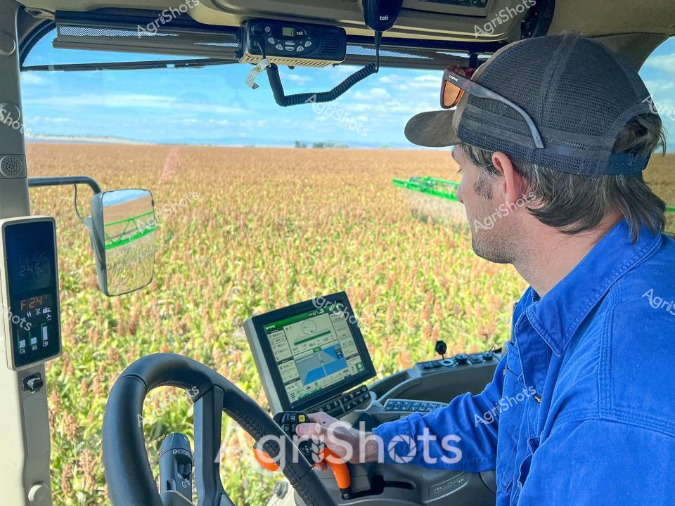
Modern agricultural precision unfolds through the cab window of a high-tech harvester, capturing the quintessential Australian grain farming experience. A skilled agricultural operator in a vivid blue work shirt and dark cap navigates a sorghum field during harvest season, surrounded by rippling golden-green crops stretching across the expansive rural landscape. Advanced digital displays and touchscreen monitors provide real-time data and GPS guidance, reflecting the sophisticated technology driving contemporary agricultural practices in regions like New South Wales. The interior of the harvester is a complex control center, with multiple screens, communication devices, and ergonomic controls allowing precise management of the crop defoliation and harvesting process. Soft clouds drift across a azure sky, creating a serene backdrop to the intense technical work of modern grain production. The scene epitomizes the fusion of agricultural expertise, cutting-edge technology, and the timeless connection between farmer and land that defines Australian agricultural innovation.
 Image
Image
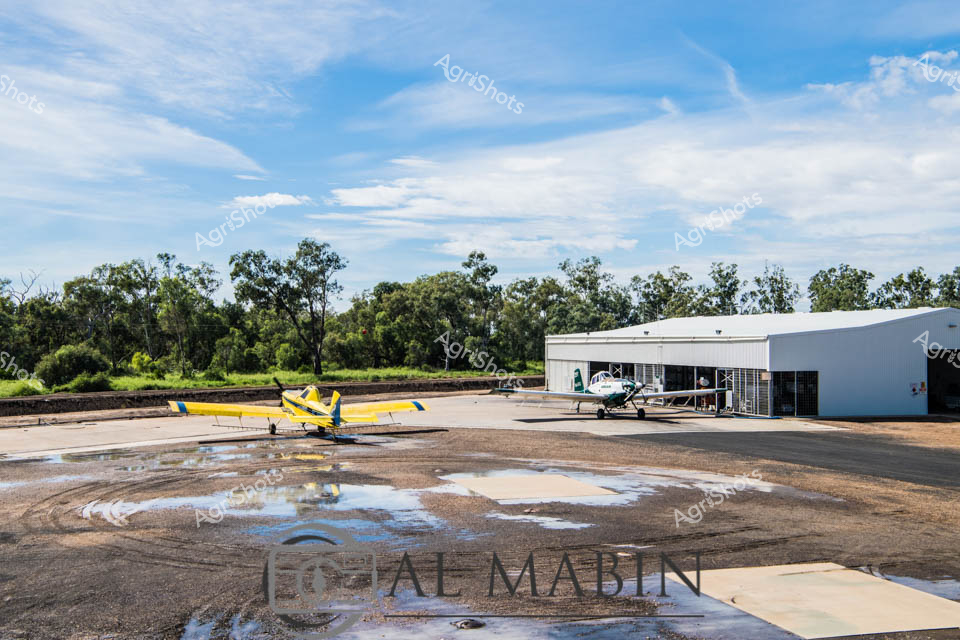
Rural Agricultural Aviation at Dawn A yellow and blue agricultural aircraft sits poised on a damp tarmac, reflecting the early morning light at a remote agricultural airstrip. Puddles from recent rain scatter across the concrete apron, creating mirror-like surfaces that reflect the surrounding eucalyptus woodland. A white hangar stands sentinel in the background, housing another agricultural aircraft, suggesting this is a specialized aerial agricultural operations base. The sky is a soft palette of blues and whites, with wispy clouds suggesting the beginning of a clear day in rural Queensland. This is the domain of crop dusting and agricultural aviation - specialized aircraft designed to support farming operations through precision crop spraying, defoliation, and aerial monitoring. The scene captures the intersection of advanced agricultural technology and the rugged Australian rural landscape, where innovative farming techniques meet the challenges of broad-acre agriculture.
 Video
Video
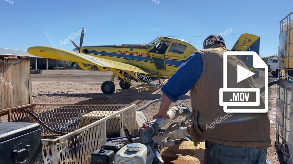
This footage captures a Queensland aerial firefighting scene featuring a vibrant yellow and blue agricultural aircraft positioned on a dusty airfield. The video clip shows a specialized firefighting plane, likely used for water or fire retardant dropping during bushfire operations, with distinctive Queensland Rural Fire Service markings. In the foreground, a worker in a blue shirt and neutral-toned vest is seen operating equipment, suggesting preparation for a potential fire response mission. The environment appears to be a remote airstrip with chain-link fencing, industrial storage containers, and a stark, arid landscape typical of Australian rural and bushland regions. The clear blue sky and bright sunlight emphasize the harsh, dry conditions that often contribute to wildfire risks. The clip powerfully illustrates the critical infrastructure and preparedness of Australian emergency services in managing bushfire threats, showcasing the specialized aircraft and dedicated personnel ready to respond to potentially devastating environmental challenges.
 Image
Image
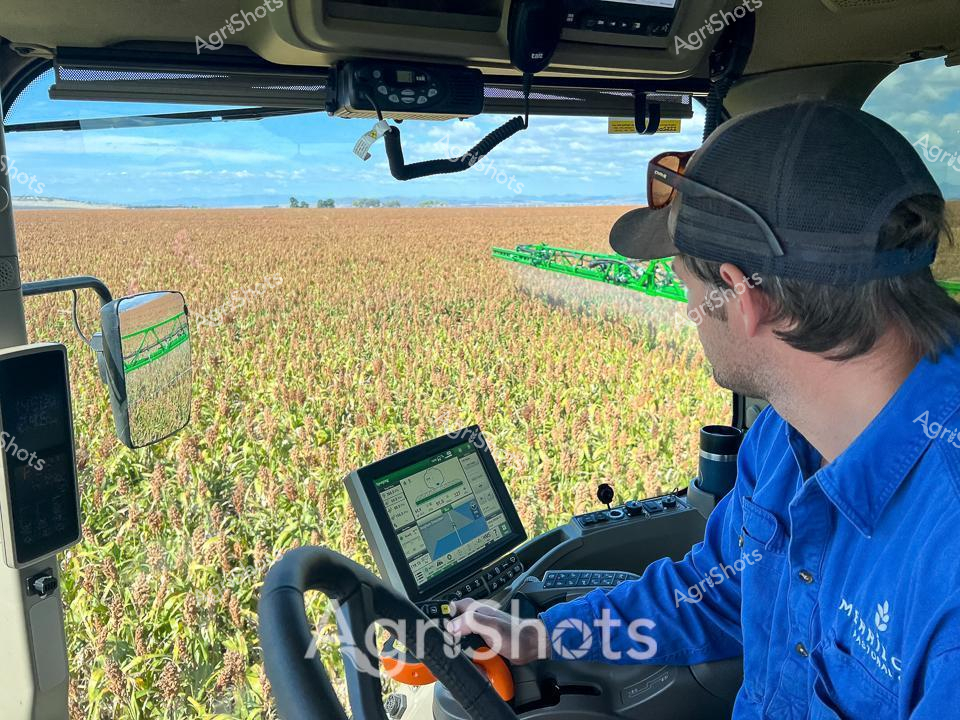
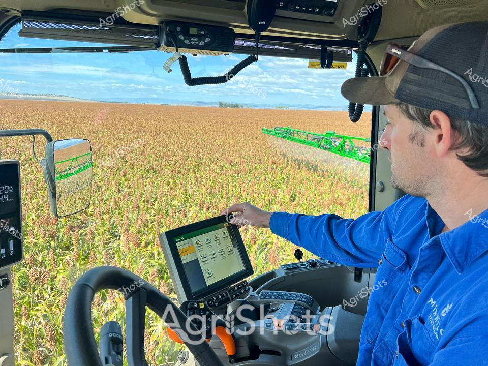
Precision agriculture meets golden sorghum horizons in this striking snapshot of modern farming technology. A farmer in a crisp blue agricultural company shirt and black cap sits within the air-conditioned cabin of a sophisticated John Deere spraying rig, navigating through ripening sorghum fields under a vast, soft blue sky. The digital touchscreen display provides real-time guidance as green spray booms extend across the uniform crop, revealing the intricate dance of precision agricultural techniques. Sunlight catches the slightly yellowing sorghum plants, signaling the approach of harvest season in what appears to be a classic New South Wales agricultural landscape. The interior of the machine is a testament to contemporary farming - complex control systems, ergonomic design, and multiple monitoring screens transforming agricultural work into a high-tech profession. This image captures the intersection of human skill, mechanical innovation, and natural cycles that define modern Australian broadacre farming.
 Video
Video
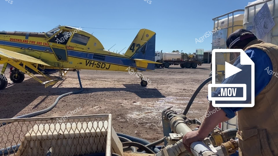
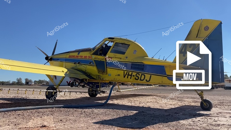
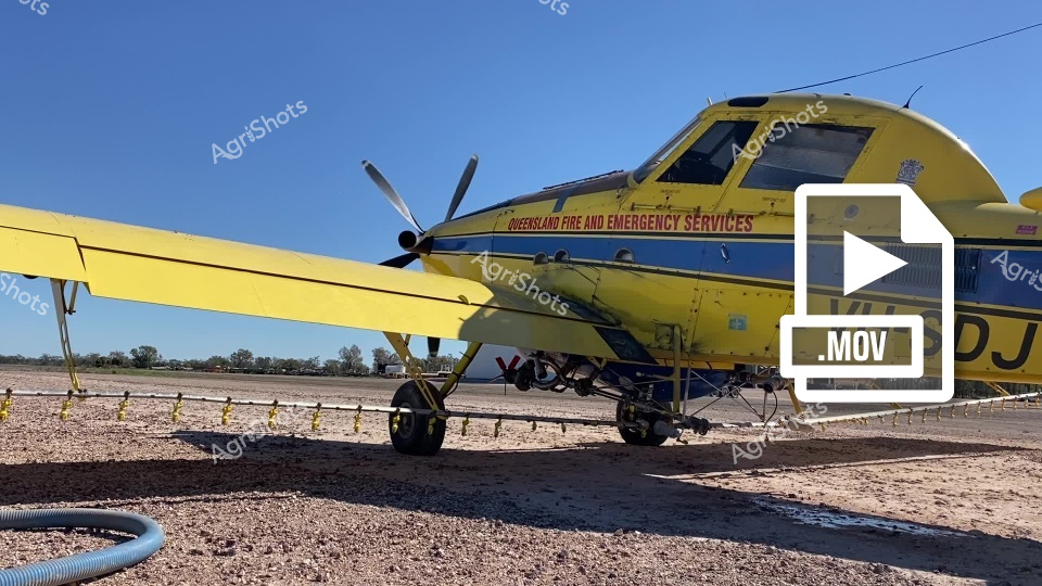
This video footage captures a Queensland Fire and Emergency Services aerial firefighting aircraft on the ground at a rural location. The clip features a bright yellow and blue aircraft, marked with "VH-SDJ", parked on a dusty, rugged terrain with various equipment and vehicles in the background. A worker in protective gear can be seen in the foreground, handling what appears to be fuel or support equipment connected to the aircraft via flexible hoses. The video showcases the critical infrastructure of aerial firefighting in Australia, with the aircraft positioned ready for potential deployment. The harsh, arid landscape surrounding the plane suggests a remote location typical of Queensland's challenging bushfire-prone regions. Metallic fencing and industrial equipment provide context to the operational setting, highlighting the preparedness and technological resources used in combating wildfires. The color palette is dominated by the aircraft's vibrant yellow and blue, contrasting sharply with the brown, dusty ground and the worker's earth-toned protective clothing. The clear blue sky and open terrain emphasize the strategic positioning of the firefighting asset, ready to respond to potential emergencies in the surrounding landscape. This clip provides an intimate look at the behind-the-scenes preparations of aerial firefighting services, demonstrating the sophisticated equipment and dedicated personnel involved in protecting Australian communities from bushfire threats.
 Image
Image
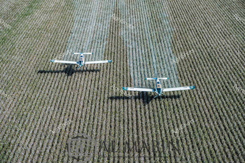
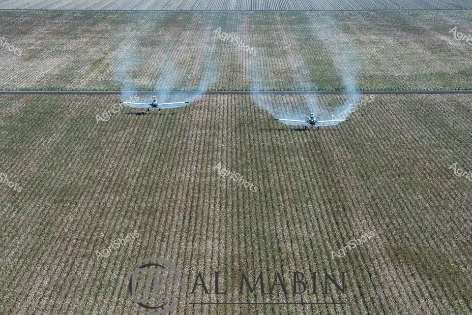
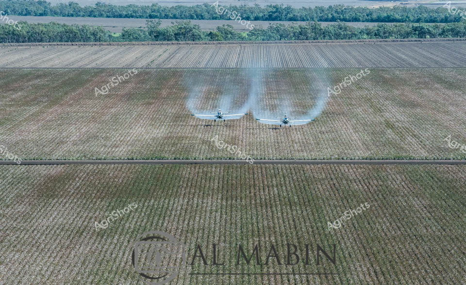
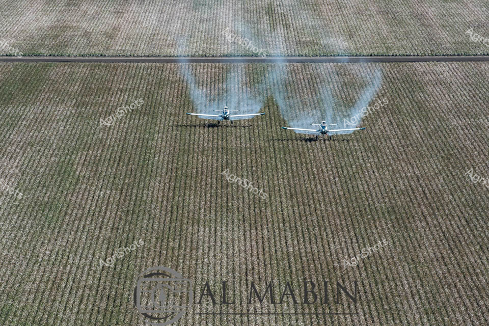
Agricultural aviation in full swing across a meticulously structured cotton field, with two specialized agricultural aircraft executing precision defoliation techniques. The expansive Queensland landscape reveals laser-straight crop rows stretching to the horizon, highlighting the disciplined geometry of modern cotton cultivation. Twin aircraft release controlled chemical sprays, creating symmetrical blue-grey mist clouds that drift methodically across the green-grey crop landscape, preparing the cotton plants for optimal harvest conditions. The overhead perspective captures the remarkable technological choreography of agricultural operations, where cutting-edge aerial application meets scientific crop management. Intense parallel lines of the planted field create a striking visual rhythm, emphasizing the scale and mathematical precision of contemporary agricultural practices. The watermarked "Ali Mabin" branding suggests this is a professional agricultural documentation, showcasing the sophisticated methodologies of Queensland's cotton industry.
 Image
Image
Precision agriculture unfolds from the cab of a high-tech John Deere spraying rig, where a farmer in a vibrant blue shirt carefully navigates through a golden sorghum field. Verdant green spray arms extend across the ripening crop, delivering targeted agricultural treatments with millimeter-perfect accuracy. Digital touchscreen controls and multiple monitoring displays transform the machinery into a sophisticated agricultural command center, reflecting the advanced technological integration of modern farming practices. The expansive paddock stretches beneath a soft blue sky with wispy clouds, suggesting a mild day in the heart of the New South Wales cropping region. Sophisticated GPS and digital mapping systems allow the operator to track every movement, ensuring optimal crop management and minimal environmental impact. This image captures the essence of contemporary Australian agricultural innovation - where cutting-edge technology, environmental consciousness, and agricultural expertise converge to produce sustainable food production.
 Image
Image
Precision agriculture unfolds across a golden sorghum field under a soft blue sky, capturing the essence of modern farming in rural New South Wales. A skilled agricultural operator in a vibrant blue work shirt navigates a high-tech John Deere spraying rig, his expert touch guiding the brilliant green boom across ripening crop rows. Digital technology merges with agricultural expertise as he carefully monitors the touchscreen display, ensuring precise application of crop treatment. The expansive paddock stretches to a distant treeline, the sorghum crop showing subtle variations of amber and green, signaling the approach of harvest season. Mounted in the air-conditioned cab, the farmer embodies the sophisticated technological approach of contemporary Australian agriculture - combining deep agricultural knowledge with cutting-edge equipment and data-driven decision making. The scene represents a moment of calculated intervention, where agricultural science and practical farming skill work in seamless harmony to maximize crop potential.
 Image
Image
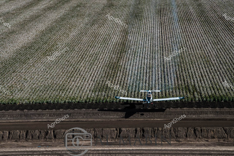
Aerial crop management unfolds across a meticulously ordered cotton field in Queensland, where a precision agricultural aircraft glides low over dense rows of silvery-green cotton plants. The specialized agricultural plane, gleaming in white and blue, demonstrates the cutting-edge defoliation technique crucial to cotton harvest preparation. Methodical rows stretch horizontally across the landscape, creating a mesmerizing geometric pattern of textured vegetation that speaks to modern agricultural efficiency. The aircraft hovers purposefully, its wings extended, casting a sharp shadow against the uniform crop rows - a visual testament to the sophisticated technological interventions that define contemporary Australian agricultural practice. The expansive field suggests the scale of cotton production in Queensland's agricultural heartland, where precision flying and targeted chemical application optimize crop management and yield potential. This aerial perspective captures the intricate dance between human engineering, technological innovation, and natural agricultural systems, showcasing the technical mastery required to transform vast landscapes into productive agricultural environments.
 Video
Video
This engaging aerial video footage captures a Queensland Fire and Emergency Services air support aircraft parked on a dry, rocky airfield under a brilliant blue sky. The bright yellow and blue aircraft, marked with "VH-SDJ", is a specialized firefighting plane designed for rural emergency response operations. The clip showcases the robust agricultural aviation sector, with the aircraft's single propeller and rugged landing gear highlighting its purpose-built design for challenging terrain and critical emergency missions. The footage provides a ground-level perspective of the aircraft, revealing intricate mechanical details and the sturdy construction needed for remote area operations. Shadows cast by the plane create interesting visual textures against the rocky, sun-baked ground, emphasizing the harsh environmental conditions these specialized aircraft must navigate. The video captures the essence of Australian emergency and agricultural aviation - a critical support system for rural and remote communities facing bushfire risks. The clear daylight and pristine condition of the aircraft suggest this is likely a preparedness or standby moment, with the plane ready to be rapidly deployed for firefighting or emergency support missions across Queensland's expansive and often fire-prone landscapes.
 Image
Image
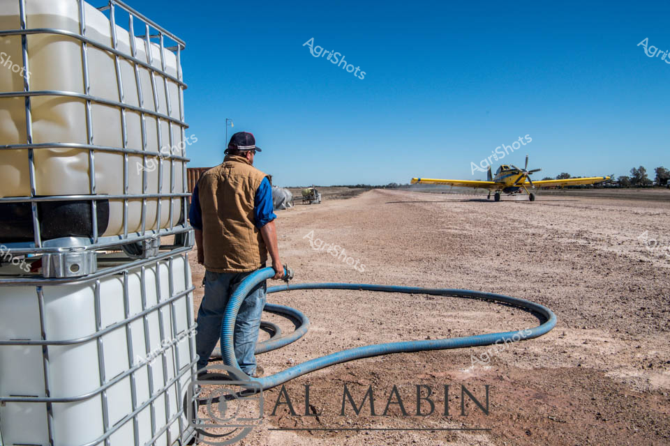
Agricultural aerial application in the arid Queensland cotton landscape: A yellow crop dusting aircraft sits poised on a dusty rural airstrip, with large industrial water tanks and agricultural infrastructure in the foreground. A worker wearing a tan work vest and cap stands near industrial intermediate bulk containers (IBC), carefully managing a blue flexible hose, preparing for crop treatment operations. The stark environment reveals a classic Australian agricultural scene - a dry, expansive terrain under a brilliant azure sky, highlighting the precision and technical sophistication of modern cotton farming practices. The image captures the intersection of advanced agricultural technology and rugged rural environments, with the yellow plane representing a critical tool in crop management and protection. The AgriShots watermark and the "Tal Mabin" branding underscore the professional documentation of this essential agricultural process. The scene embodies the resilience and technical expertise required in Queensland's challenging agricultural sectors, particularly in cotton production and crop management.
 Image
Image
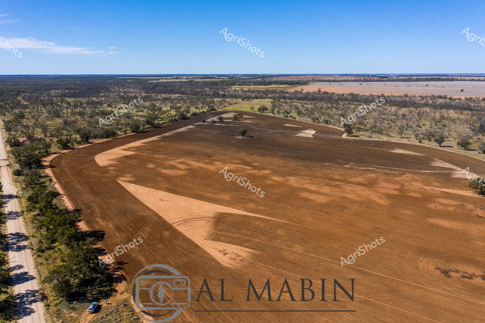
Sprawling across the rich Queensland landscape, a recently defoliated cotton field reveals its raw, earthy beauty under a crisp blue sky. The meticulously prepared paddock displays warm bronze and rust-colored tones, with distinctive tractor lines etched into the soil, showcasing precision agricultural techniques. Surrounding native bushland frames the field, creating a stark contrast between the carefully cultivated earth and the natural woodland. Sparse eucalyptus trees dot the field's edge, providing natural landmarks in this expansive agricultural setting. The aerial perspective captures the immense scale of modern farming, highlighting the sophisticated land management practices of Australian cotton producers. Shadows and contours created by agricultural machinery reveal the intricate process of preparing the field for cotton harvest, a critical moment in the agricultural calendar that represents months of careful cultivation and strategic land preparation.
 Image
Image
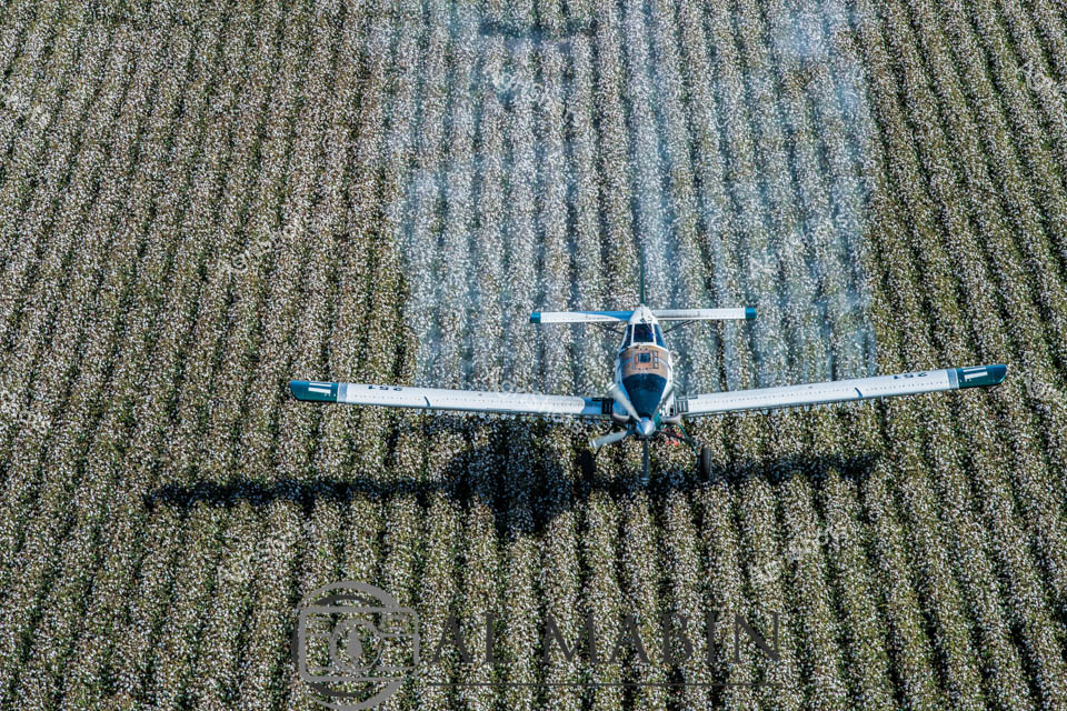
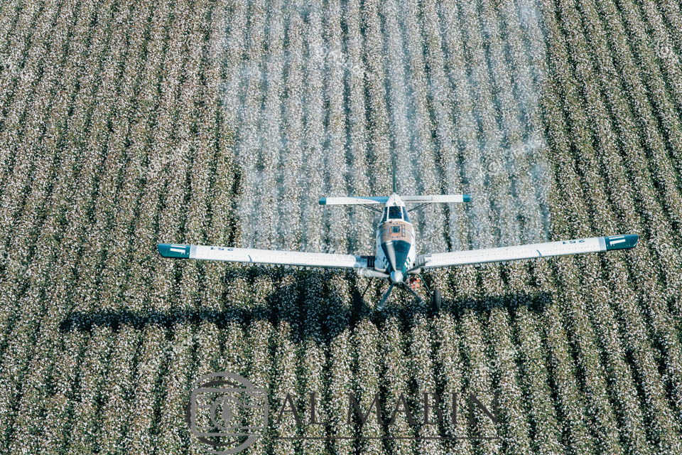
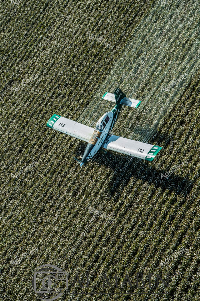
Precision agriculture takes flight over a meticulously cultivated cotton field, where an agricultural aircraft navigates between uniform rows of mature cotton plants. The sleek blue and white crop duster hovers low, its wings spread wide against the intricate geometric pattern of silvery-green foliage, preparing to apply defoliant in preparation for harvest. Queensland's expansive agricultural landscape stretches beneath the plane, demonstrating the sophisticated technology modern farmers employ to maximize crop yield and efficiency. The aerial view reveals the mathematical precision of modern cotton cultivation - each row perfectly aligned, each pass of the aircraft calculated to optimize crop management. Soft blue and white tones of the aircraft contrast beautifully with the muted green and silver textures of the cotton field, capturing the harmonious intersection of technological innovation and natural agricultural production. This image epitomizes the cutting-edge approach of Australian agricultural practices, where advanced machinery and strategic environmental management combine to produce one of the world's most valuable fiber crops.
 Image
Image
Aerial Agricultural Defoliation: Cotton Field Preparation Twin agricultural aircraft sweep low across expansive Queensland cotton fields, releasing precise plumes of defoliant to prepare the crop for harvest. The meticulously planted rows stretch horizontally, creating a geometric landscape of soft earth tones and subtle textural variations. Precision agricultural technology is on full display as the planes navigate mere meters above the field, their synchronized spray patterns creating a misty veil across the mature cotton crop. Dense eucalyptus woodland frames the background, providing a rich green contrast to the silvery-grey field. The watermarked "Al Mabin" branding suggests this is the work of a renowned Australian agricultural photographer capturing the critical late-season process of cotton crop management. The image encapsulates the technical sophistication and strategic planning inherent in modern broad-acre farming, highlighting the intricate dance between technology, natural environment, and agricultural productivity.
 Image
Image
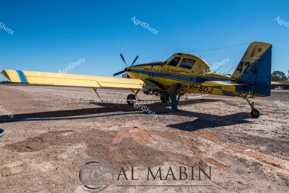
Agricultural aerial support takes flight in this vivid snapshot of precision agricultural services. A striking yellow and blue agricultural aircraft sits poised on a dusty rural airstrip, clearly configured for crop defoliation and agricultural survey work. The aircraft, marked with registration VH-SDJ, represents the specialized aerial services critical to modern Australian farming operations, particularly in cotton-growing regions of Queensland. Its robust design features wide wingspan and a single propeller, optimized for low-altitude operational capabilities across expansive agricultural landscapes. The harsh, sun-baked earth surrounding the aircraft speaks to the challenging environmental conditions of inland agricultural zones, with rocky, compacted ground casting sharp shadows beneath the plane's undercarriage. This image captures the technical sophistication and rugged resilience of Australian agricultural aviation, highlighting the specialized equipment that supports broad-acre farming strategies in remote and demanding terrains.
 Image
Image
Aerial crop management in full swing, a sleek blue and white agricultural plane glides low over a lush cotton field, casting a crisp shadow across the meticulously planted rows. The aircraft, a precision instrument of modern farming, navigates carefully between the dense green rows of cotton plants, likely engaged in defoliation or pest control operations typical of the Queensland cotton growing region. Verdant green rows stretch uniformly across the landscape, creating a textured carpet of agricultural productivity that demonstrates the meticulous planning and technological sophistication of contemporary cotton cultivation. The bird's-eye perspective reveals the immaculate geometry of the plantation, with each row perfectly aligned and the plane positioned as a strategic tool in maximizing crop yield and quality. The cool blue tones of the aircraft contrast sharply against the rich green of the cotton field, symbolizing the intersection of technology and nature in Australian agricultural practice. This image captures the precise, calculated approach of modern farming - where aerial technology meets agricultural expertise to optimize crop management in the challenging Queensland agricultural landscape.
 Image
Image
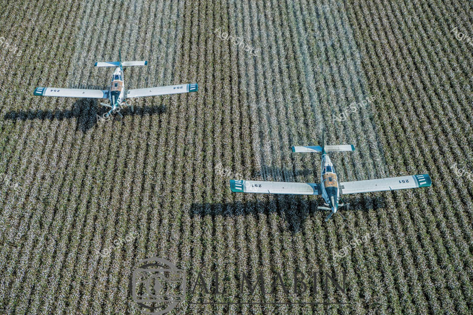
Agricultural aerial defoliation transforms the landscape as two precision agricultural aircraft glide low over a meticulously planted cotton field. Blue and white crop-dusting planes execute a synchronized agricultural ballet, their wings casting sharp shadows across the regimented rows of green-grey cotton plants. The aerial spraying operation represents the pinnacle of modern farming technology, where GPS-guided aircraft deliver targeted chemical treatments to prepare the cotton crop for efficient mechanical harvesting. The geometric precision of the cultivated field contrasts beautifully with the dynamic movement of the aircraft, their sleek frames marked with identifying numbers against the mottled green and silver texture of the maturing cotton plantation. Queensland's expansive agricultural landscape unfolds beneath the planes, revealing the sophisticated engineering and strategic planning required in contemporary large-scale cotton production. These specialized agricultural aircraft demonstrate the advanced techniques used by Australian farmers to manage crop health, optimize yield, and prepare fields for harvest. The defoliation process - chemically removing leaves to facilitate mechanical harvesting - represents a critical moment in the cotton production cycle, showcasing the intersection of agricultural science, technological innovation, and environmental management.
 Image
Image
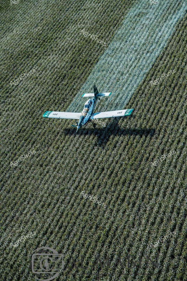
Agricultural aerial survey of a cotton field during defoliation season in Queensland, revealing precision agricultural practices. A sleek agricultural spraying plane hovers low over a meticulously planted cotton crop, its white and teal livery contrasting against the dense green and grey-green mosaic of the mature cotton field. The aircraft, marked with identification numbers, demonstrates the critical role of aerial application in modern farming - strategically distributing defoliant chemicals to prepare the crop for mechanical harvesting. The geometric regularity of the crop rows speaks to careful planning and advanced agricultural techniques, with each row creating subtle textural variations across the landscape. Sunlight casts a sharp shadow beneath the aircraft, emphasizing the precise low-altitude flight path and highlighting the sophisticated technological approach to crop management. This image encapsulates the cutting-edge intersection of aviation, agricultural science, and large-scale farming in the Australian cotton industry, showcasing Queensland's sophisticated agricultural landscape.
 Video
Video
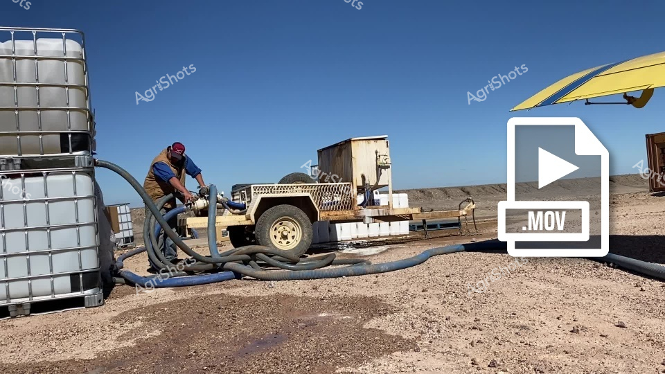
The footage captures an agricultural operations scene in a remote, arid location, likely in the Australian outback. A worker in a blue shirt and red cap is carefully managing fluid transfer using large industrial containers and flexible hoses connected to a rugged utility vehicle. The environment is a stark, dusty landscape with a clear blue sky, suggesting a harsh midday setting typical of dry agricultural regions. The video clip features a robust utility vehicle with a tan/cream chassis positioned between large white industrial fluid containers (IBC tanks). Flexible blue and black hoses snake across the ground, indicating a complex liquid transfer or irrigation setup. The terrain is rocky and barren, with compacted earth and scattered gravel, highlighting the challenging working conditions of remote agricultural sites. The worker appears focused and methodical, bent over the equipment and carefully managing the connection and flow of liquids. His work attire - a blue shirt, brown work pants, and a red cap - is practical and suited to the harsh environmental conditions. The yellow sun shade in the background provides a small respite from the intense sunlight. This footage effectively captures the technical complexity and resilience required in agricultural operations in extreme environments, showcasing the specialized equipment and dedicated workers who maintain critical infrastructure in remote locations.
 Video
Video
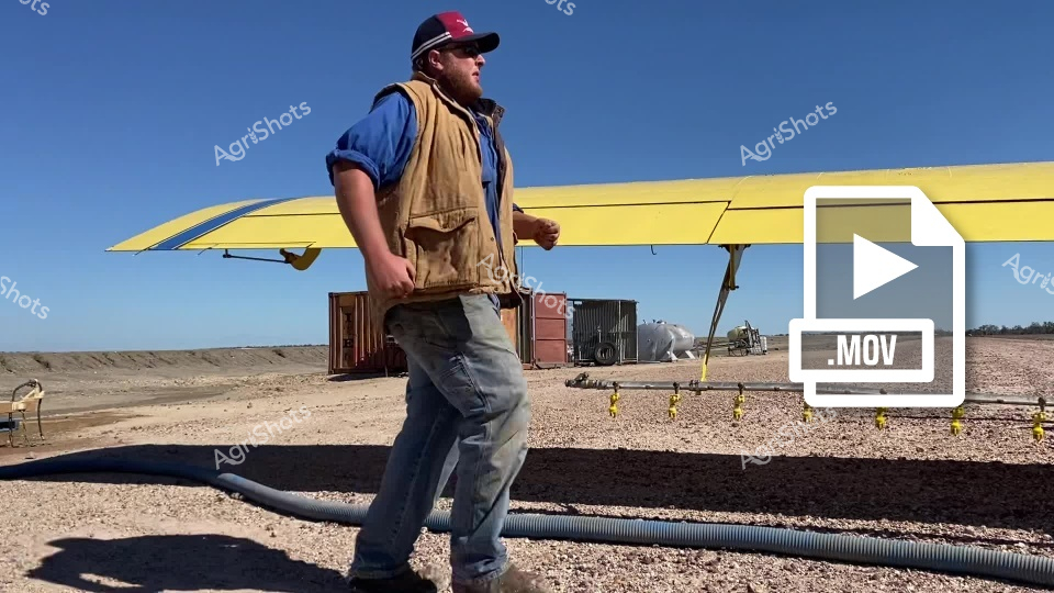
This video footage captures a worker in an industrial agricultural setting, positioned near a yellow aircraft wing or solar panel structure. The clip showcases a rugged outdoor environment with shipping containers, rocky terrain, and a clear blue sky, suggesting an arid or remote location. The worker is dressed in practical workwear - a tan utility vest, blue shirt, gray work pants, and a red baseball cap. He stands confidently, facing sideways, with corrugated pipes and equipment visible in the foreground. The scene appears to be a remote work site, potentially related to agricultural or industrial operations in an arid region. The video clip seems to document daily operations in a challenging outdoor environment, highlighting the resilience and preparedness of workers in remote industrial settings. The yellow structure, metallic containers, and rocky ground create a stark, high-contrast landscape that emphasizes the harsh working conditions. The footage captures a moment of pause or observation, with the worker seemingly surveying the surrounding environment. The bright sunlight, clear sky, and open terrain suggest this is likely a daytime scene in a dry, possibly drought-affected region.
 Image
Image
Aerial agricultural artistry unfolds across a vast Queensland cotton field, where two precision agricultural aircraft execute a synchronized defoliation dance. Crisp white planes glide mere meters above the meticulously planted rows, releasing billowing plumes of silvery-blue spray that drift gracefully across the structured landscape. The geometric perfection of the cotton rows creates a mesmerizing textural canvas, with each carefully planted line revealing the methodical approach of modern agricultural practice. Almab branding anchors the image, signaling the professional agricultural operation at work, while the aerial spraying represents a critical stage in cotton production - preparing the crop for efficient mechanical harvesting. The soft muted greens and greys of the field contrast dramatically with the sharp white of the aircraft, capturing the technical elegance of contemporary farming techniques. This image epitomizes the high-tech, precision-driven nature of Australian agricultural innovation, showcasing how cutting-edge technology transforms vast rural landscapes into productive, scientifically managed ecosystems.
 Video
Video
This video footage captures a Queensland Fire and Emergency Services aircraft positioned on a dry, dusty airfield under a clear blue sky. The bright yellow aircraft, designed for firefighting operations, stands ready with its distinctive propeller and robust frame, showcasing the critical infrastructure used in managing bushfire risks across rural Australia. The clip features the aircraft parked on a rocky, arid terrain with sparse vegetation visible in the background, highlighting the challenging environmental conditions typical of Australian fire-prone regions. The video emphasizes the specialized equipment used in emergency response, with the aircraft's vibrant yellow color providing high visibility and signaling its important public service role. A flexible hose can be seen near the aircraft, suggesting preparation for water or firefighting fluid deployment. The stark landscape and professional-grade emergency response vehicle communicate the ongoing vigilance required in protecting communities from the ever-present threat of bushfires in the Australian outback. The scene captures the intersection of advanced technological preparedness and the harsh, unforgiving natural environment, embodying the resilience and strategic planning of Australian emergency services in managing wildfire risks.
Well, you've ploughed through the whole field!
No more crops to harvest here, mate.
Try searching for something else in our library of 50,000+ royalty-free media: