 Video
Video
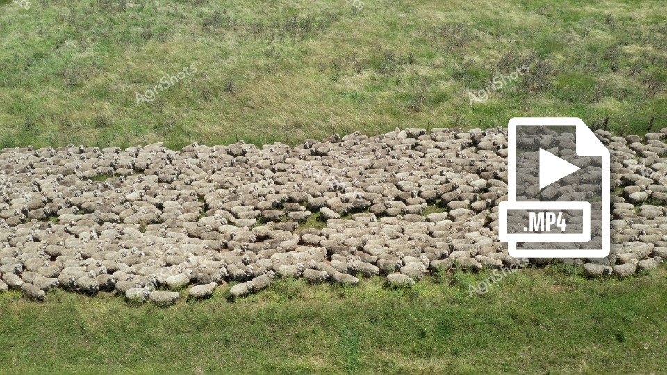
Densely packed Merino sheep huddle together in a tight formation across a lush pastoral landscape, creating a living carpet of woolly bodies against the verdant grasslands of New South Wales. The mob stretches from one grassy bank to another, their uniform fleeces blending into a seamless mass of creamy white and soft gray tones. Sparse shrubs and native grasses frame the edges of the flock, suggesting this is likely a mustering scene where skilled working dogs and stockmen have gathered the sheep for movement or management. The tight clustering indicates precision livestock handling, a hallmark of Australian agricultural expertise - each animal positioned closely to the next, creating an almost geometric pattern of woolly backs and subtle texture. Soft green and brown hues of the surrounding landscape contrast beautifully with the pale sheep, capturing the quintessential rural Australian pastoral environment. The MP4 video icon suggests this is a dynamic scene, likely documenting the movement and management of a substantial Merino sheep flock during a typical farming operation.
 Image
Image
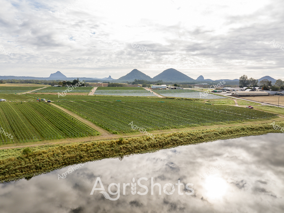
Undulating green pastures cascade across the New England landscape, where precision agricultural practices meet dramatic mountain horizons. Meticulously divided crop fields stretch toward distant volcanic peaks, creating a geometric tapestry of agricultural innovation. A pristine waterway winds along the foreground, its banks protected by carefully maintained vegetation, representing best-practice riparian zone management. The overcast winter sky casts soft, diffused light across verdant paddocks, highlighting the strategic layout of farming infrastructure and water management systems. Regenerative farming principles are evident in the carefully planned field divisions, erosion control, and strategic water exclusion fencing that protects both agricultural productivity and environmental sustainability. The scene captures the delicate balance between human agricultural intervention and the natural landscape, with geometric field patterns contrasting against the rounded silhouettes of distant mountain ranges in a quintessential Australian rural tableau.
 Image
Image
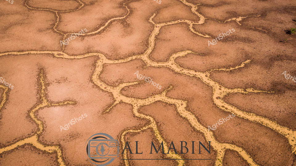
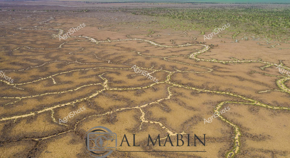
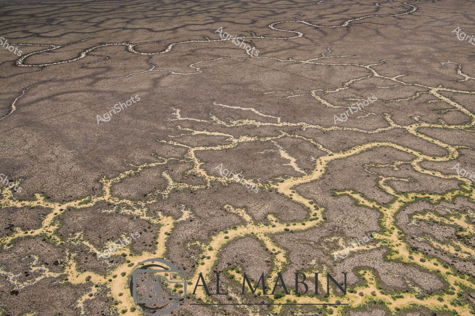
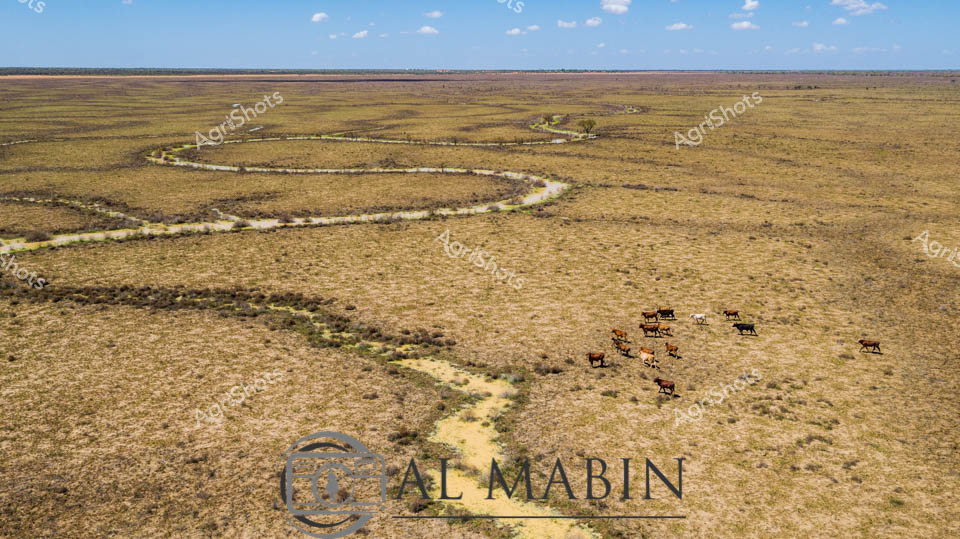
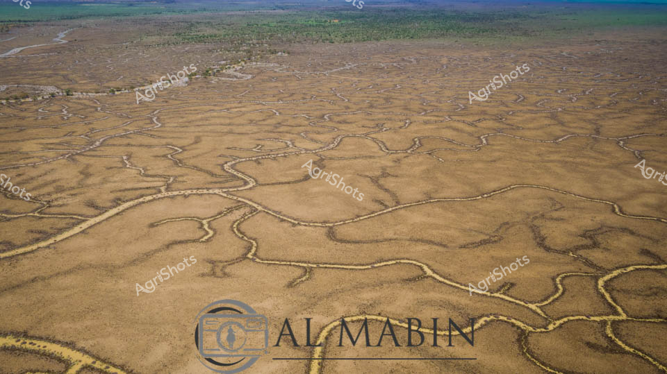
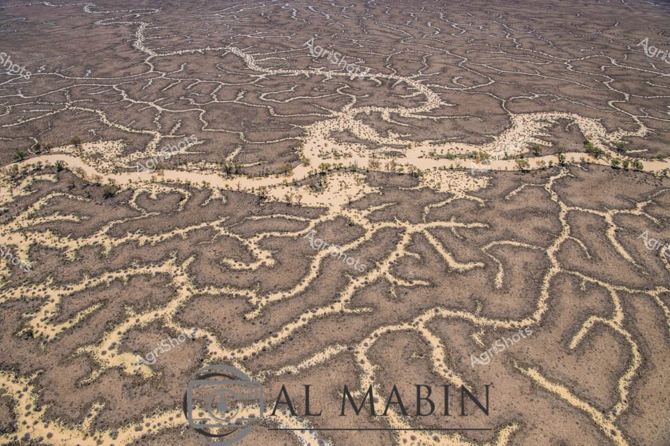
Serpentine waterways carve intricate patterns across the arid landscape of Queensland's Channel Country, revealing the ephemeral beauty of desert hydrology. Golden-brown tributaries snake across a dusty terracotta surface, tracing the delicate network of ancient creek lines and seasonal river channels that define this harsh but mesmerizing ecosystem. The aerial perspective captures the geological artistry of water movement, where each branching stream tells a story of rare flooding and survival in one of Australia's most unforgiving environments. Windorah's legendary inland waterways demonstrate nature's remarkable capacity to create complex, organic designs that pulse with life-giving moisture across seemingly barren terrain. The intricate golden-edged channels suggest the transient power of water in transforming this landscape, highlighting the critical role of seasonal floods in sustaining the fragile ecological balance of central Queensland's remote pastoral zones. The AgrShots watermark andOtal Mabin branding anchor this stunning representation of Australia's inland hydrology, celebrating the raw, elemental beauty of the continent's most challenging agricultural regions.
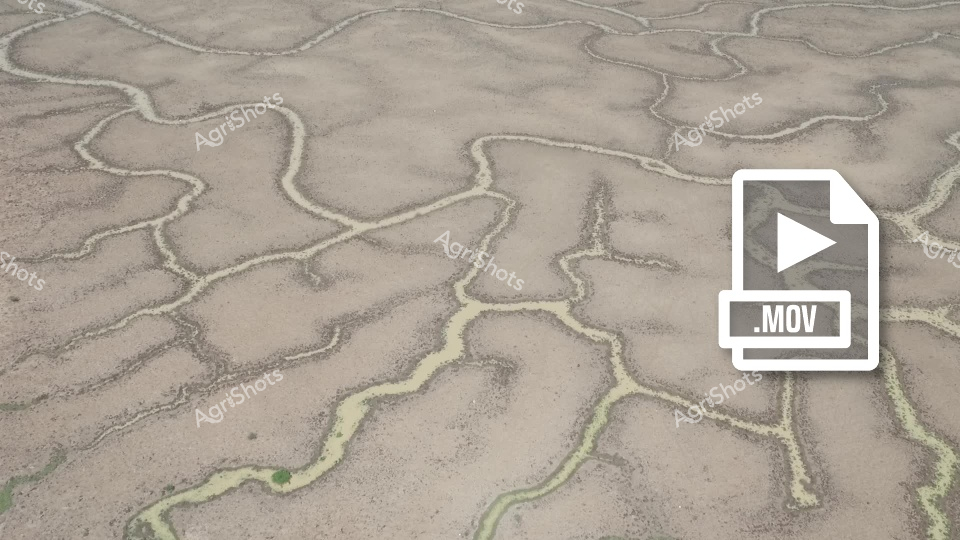
 Video
Video
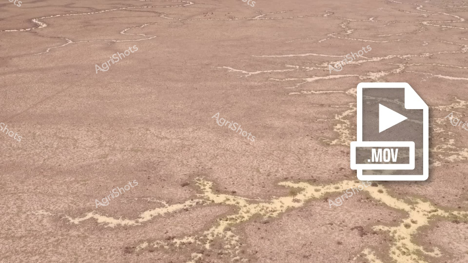
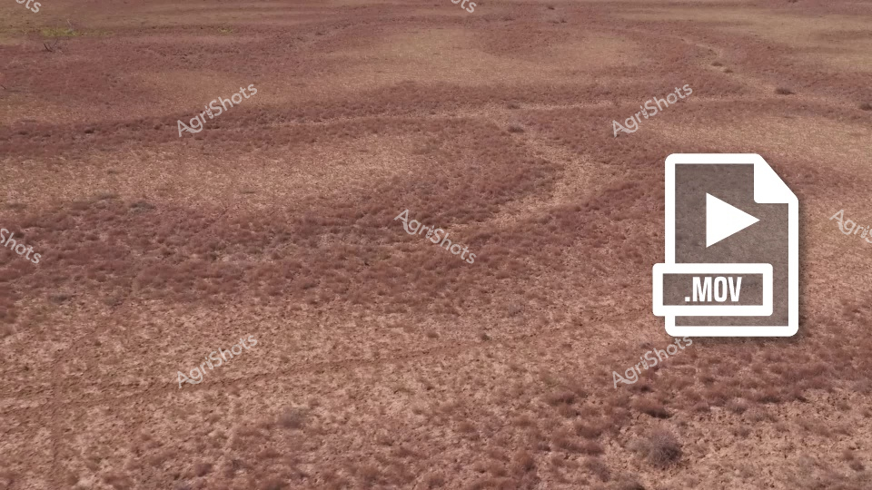
This video footage captures a stark, arid landscape revealing the harsh realities of drought conditions in an Australian agricultural region. The scene presents a parched, cracked earth with intricate, serpentine patterns of dried and yellowed vegetation winding across the barren ground. The color palette is predominantly muted browns and dusty tans, highlighting the extreme dryness of the terrain. The clip appears to document the devastating impact of prolonged water scarcity on a rural landscape, potentially in a region like South Australia or Queensland. Sparse, withered vegetation traces delicate, almost fractal-like patterns across the ground, creating a sense of desolation and environmental stress. These dried vegetation trails contrast against the uniform, baked earth, illustrating the challenging conditions faced by farmers and ecosystems during severe drought periods. The video seems designed to capture the raw, unfiltered reality of agricultural landscapes during water shortages, providing a powerful visual narrative about climate resilience and the environmental challenges confronting Australian farming communities. The stark, minimalist composition emphasizes the profound environmental transformation wrought by extended periods without adequate rainfall. The footage powerfully communicates the vulnerability of agricultural landscapes to climatic extremes, serving as a critical documentation of environmental change and rural adaptation strategies.
 Image
Image
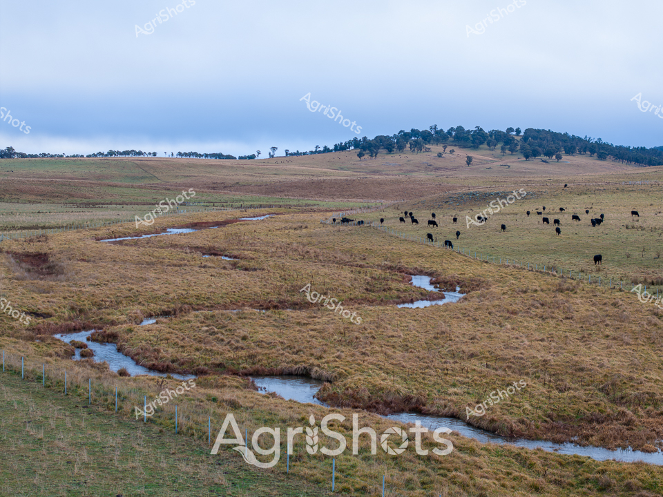
Pristine winter pastures of the New England Region unfurl across undulating hills, where a meandering creek traces a sinuous path through native grasslands. A herd of Black Angus cattle graze peacefully, their dark forms a stark contrast against the muted golden and brown landscape. Carefully placed exclusion fencing lines the waterway, protecting the delicate riparian zone and demonstrating modern regenerative farming practices that balance agricultural productivity with environmental stewardship. Scattered eucalyptus trees punctuate the distant hillsides, their silhouettes adding depth to the expansive pastoral scene. The creek's gentle curves reflect the soft winter light, creating a tranquil blue-grey ribbon that winds through the carefully managed landscape. Each element speaks to the sophisticated approach of New South Wales farmers who understand the intricate relationship between livestock, water systems, and land health. The image captures the essence of sustainable cattle farming - a harmonious blend of agricultural enterprise and ecological mindfulness. Rolling pastures stretch to the horizon, with the Angus herd moving slowly, grazing contentedly in a landscape that tells a story of careful land management and deep connection to the Australian rural environment.
 Image
Image
Serpentine waterways thread through the arid Channel Country of Queensland, capturing the ephemeral beauty of this remote pastoral landscape. Intricate river channels meander across the ochre-brown earth, creating a complex network of water tributaries that pulse with life during seasonal flood events. The aerial perspective reveals the stunning geological artistry of natural water distribution, where each sinuous channel carves delicate pathways across the expansive floodplains. Sparse vegetation in muted greens and yellows punctuates the broader landscape, highlighting the resilient ecosystem of this harsh yet magnificent Australian outback region. Soft blue skies with gentle cloud formations stretch endlessly above the terrain, providing a luminous backdrop to the earth's remarkable hydological patterns. This extraordinary landscape represents the lifeblood of beef stations in Queensland's remote interior, where water management and natural flooding cycles are critical to sustainable pastoral agriculture.
 Image
Image
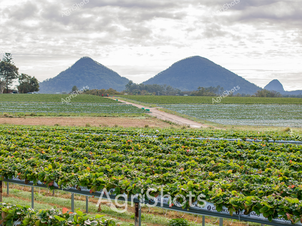
Lush strawberry fields stretch across the foreground, revealing meticulously organized rows of vibrant green plants on raised metal frames. The agricultural landscape unfolds beneath a dramatic clouded sky, with a striking backdrop of rounded mountain peaks creating a majestic horizon. Neat irrigation channels divide the cultivated sections, highlighting the precision of modern agricultural techniques in this fertile growing region. Soft green and brown tones dominate the scene, with hints of red fruit peeking through the dense foliage, suggesting a bountiful harvest in progress. The panoramic vista captures the essence of Australian agricultural innovation, where careful land management and advanced farming methods transform the landscape into a productive ecosystem. The interplay between cultivated fields and natural mountain terrain creates a compelling visual narrative of human agricultural endeavor harmonizing with the surrounding environment.
 Image
Image
Midnight-black Angus cattle graze across a frost-touched winter pasture in New England's high country, their sleek forms creating a rhythmic pattern against the muted gold and grey landscape. A meandering creek winds through the foreground, its reed-fringed banks lined with blue exclusion fencing - a hallmark of progressive riparian zone management. Bare pine trees stand sentinel in the background, casting long shadows across paddocks where regenerative farming practices are clearly at work. The cattle, likely from a premium stud breeding program, move with calm deliberation across undulating terrain, their robust frames testament to the robust health of the herd and the carefully managed landscape. Soft winter light bathes the scene in subdued tones, highlighting the careful balance between agricultural productivity and environmental stewardship typical of New South Wales' sophisticated farming approaches. This image captures the quiet dignity of Australian pastoral agriculture - where livestock, landscape, and sustainable practice exist in harmonious connection.
 Image
Image
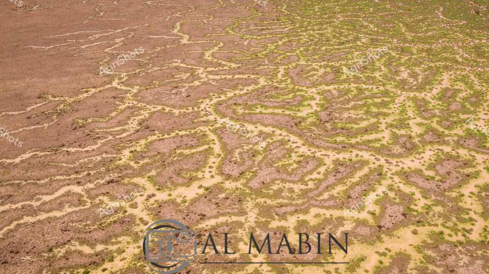
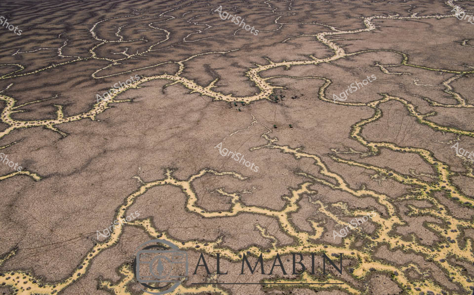
Branching waterways weave an intricate network across the parched Channel Country landscape, revealing the ephemeral lifelines of Queensland's remote interior. Limestone-edged creek lines trace delicate golden-green pathways through ochre and umber plains, capturing the subtle hydrology of an arid pastoral ecosystem. During rare flood events, these seemingly fragile watercourses transform the landscape, carrying vital moisture across vast cattle station territories and sustaining native grasses that support extensive beef production. The aerial perspective unveils a natural irrigation system where water navigates subtle topographical contours, creating a mesmerizing organic pattern that speaks to the resilience of Australia's inland agricultural environments. Soft green vegetation clusters along the watercourse edges contrast with the dominant brown earth, highlighting the critical role of water in this unforgiving terrain. The Al Mabin watermark signals this as a professional agricultural landscape documentation, capturing the strategic beauty of Queensland's remote pastoral zones.
 Image
Image
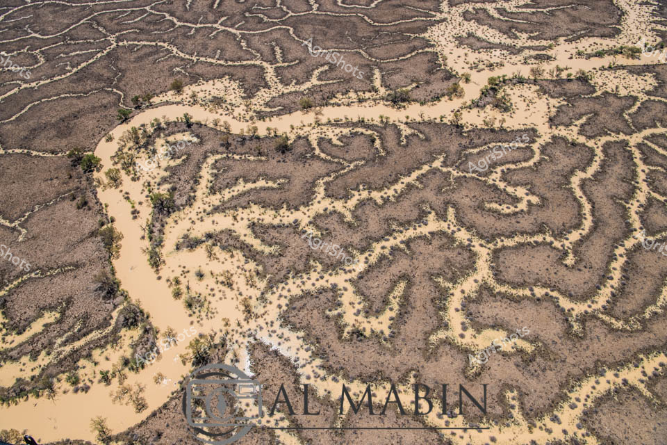
Aerial vista of Channel Country's ephemeral waterways near Windorah, Queensland, revealing the intricate capillary-like network of seasonal creek systems during a rare flooding event. Silvery-white water tendrils fracture the ochre and umber landscape, tracing delicate branching patterns across the arid terrain like living arteries. The main watercourse glows with a burnished golden-brown hue, carrying life-giving moisture through the parched plains, with sparse vegetation clinging to its edges in resilient clusters of olive and sage green. This extraordinary landscape demonstrates the transformative power of water in Australia's harsh interior, where brief moments of abundance reshape the seemingly dormant ecosystem. The complex hydrological system illustrates the remarkable adaptation of beef stations in Queensland's remote Channel Country, where pastoral management relies on understanding these dynamic, intermittent water flows. From this elevated perspective, the landscape appears almost abstract - a stunning natural cartography of survival and renewal in one of the world's most challenging agricultural environments.
 Image
Image
Aerial rivers of liquid silver meander across the parched Channel Country landscape, tracing delicate waterways through the rich ochre and umber earth of western Queensland. Flood waters from distant rains create an intricate network of serpentine channels, transforming the arid terrain into a complex hydological tapestry. Stunted trees with pale golden foliage cluster along the watercourse, providing rare points of vertical relief in this expansive horizontal panorama. The landscape reveals the extraordinary resilience of Australia's inland ecosystems, where ephemeral water systems breathe temporary life into seemingly dormant ground. Windorah's legendary beef station country displays its remarkable geological complexity, with each sinuous water channel revealing the subtle topographical variations that define this harsh yet beautiful environment. The aerial perspective captures the raw, elemental beauty of Queensland's remote interior, where water is the most precious and transformative element in an otherwise unforgiving landscape.
 Image
Image
Aerial vista of Channel Country's ephemeral river system near Windorah, Queensland, revealing nature's intricate hydraulic artistry. Serpentine waterways trace delicate green-edged channels across an ochre landscape, demonstrating the extraordinary hydrology of Australia's arid interior. Seasonal flooding has transformed the dusty terrain into a complex network of interconnected streams, where sparse vegetation follows the moisture's meandering path. The landscape displays a mesmerizing pattern of brown earth interwoven with subtle green vegetation, highlighting the resilient ecosystem's adaptation to extreme environmental conditions. Each sinuous watercourse represents a lifeline through this harsh pastoral region, illustrating how water shapes and sustains life in one of the continent's most challenging agricultural environments. This remarkable aerial perspective captures the dynamic interaction between water, soil, and sparse vegetation in Queensland's remote Channel Country, a critical region for extensive beef cattle stations.
 Image
Image
Aerial vista of Channel Country's intricate water management system, revealing the complex network of ephemeral creek channels carved across an arid Queensland landscape. Serpentine waterways weave like silvery veins across the dusty earth, creating an extraordinary natural irrigation pattern that transforms during rare flooding events. The branching channels, etched delicately into the ochre and sienna terrain, demonstrate the remarkable hydraulic engineering of this remote Australian pastoral region. Distant green vegetation marks the landscape's edges, contrasting against the pale brown ground and meeting a luminous azure sky scattered with wispy white clouds. These natural water distribution channels are critical infrastructure for beef cattle stations, capturing and dispersing precious rainfall across vast, otherwise inhospitable plains. The image captures the extraordinary resilience and adaptive strategies of Australian agricultural landscapes, where water management is an art form sculpted by geological and climatic forces.
 Image
Image
An intricate aerial view of Channel Country reveals a complex network of braided waterways and dry creek beds stretching across an arid Queensland landscape. Serpentine rivers wind through the parched terrain, creating an organic, maze-like pattern of silver and ochre channels that reflect the unique hydrology of this remote Australian outback region. The landscape captures the harsh beauty of drought-affected inland Australia, with sparse vegetation and meandering water courses etched into the sun-baked earth.
 Image
Image
Aerial view of Channel Country's intricate water network, revealing the lifeblood of Queensland's arid pastoral landscapes. Serpentine waterways trace delicate golden-edged patterns across a weathered grey terrain, creating an organic network that resembles complex veins traversing dry earth. These ephemeral creek channels, characteristic of inland Australia's flood plains, demonstrate nature's remarkable hydraulic engineering during seasonal inundation. Soft yellowed vegetation punctuates the margins of these waterways, highlighting the subtle transition between water and land in this harsh yet resilient ecosystem. The aerial perspective captures the immense scale and fragile beauty of inland waterways that sustain vast cattle stations and support unique desert ecosystems. This landscape represents the extraordinary adaptive strategies of Australian agricultural environments, where water management is crucial to survival.
 Image
Image
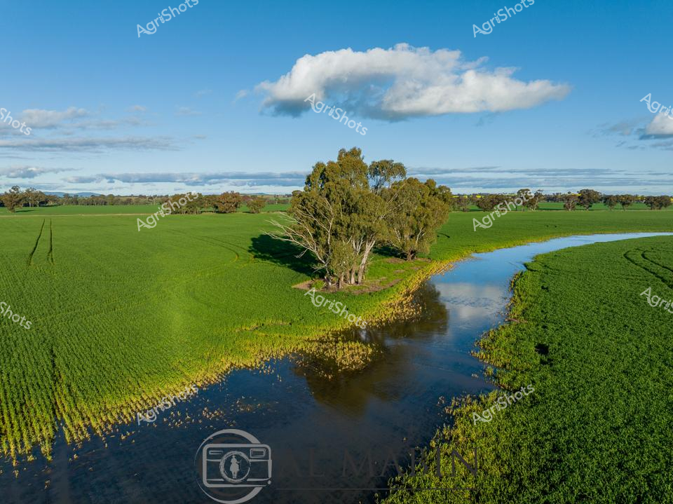
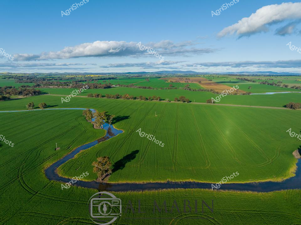
Verdant wheat fields embrace a sinuous creek in the heart of New South Wales, capturing the lush agricultural landscape of an early morning in late winter or early spring. Brilliant emerald rows of young wheat stretch across the undulating terrain, punctuated by a cluster of weathered gum trees clustered around the water's edge. A majestic white cloud drifts lazily above a horizon of soft blue sky, casting gentle shadows across the vibrant green paddocks. The creek meanders through the agricultural vista, its reflective surface mirroring the surrounding landscape and creating a natural boundary between precisely planted crop sections. Native eucalyptus trees stand as silent sentinels, their silvery bark and dense green foliage providing a textural contrast to the uniform wheat crop. This aerial perspective reveals the intricate relationship between water, land, and agricultural precision that defines the Australian rural landscape, showcasing the meticulous care and natural beauty of broadacre farming in one of Australia's most productive agricultural regions.
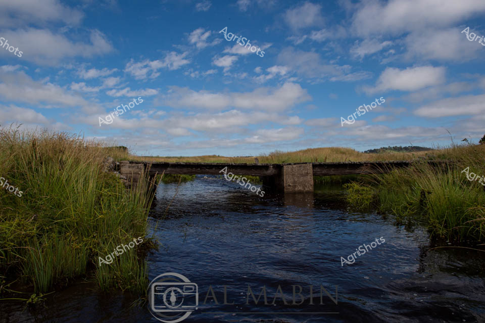
 Image
Image
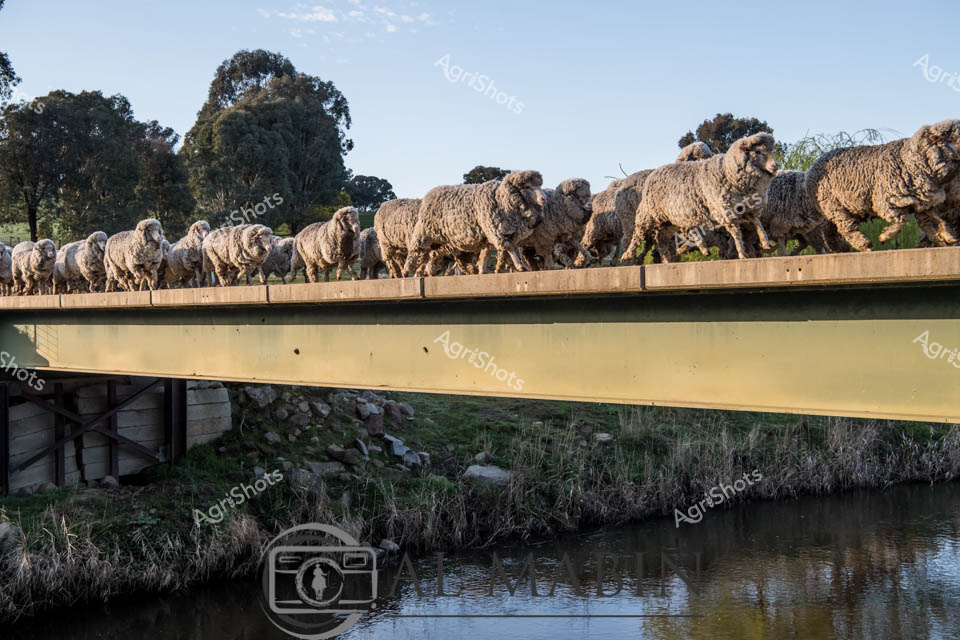
Merino wethers traverse a rustic timber bridge, their dense, silvery-white fleece gleaming in the soft morning light. The carefully managed flock moves in disciplined formation across the sturdy crossing, suspended above a tranquil creek lined with native grasses and scattered river stones. Muscular and robust, these premium wool-producing sheep represent the pinnacle of Australian agricultural breeding, their uniform size and condition a testament to expert livestock management. Surrounding eucalyptus trees cast gentle shadows, creating a quintessential rural Australian landscape that speaks to generations of pastoral heritage. The bridge serves not just as a physical crossing, but as a metaphor for the connection between land, animal, and farmer - a delicate infrastructure supporting the robust wool industry. Early daylight bathes the scene in a golden-green palette, capturing the timeless rhythm of mustering and the quiet efficiency of sheep transportation across challenging terrain.
 Image
Image
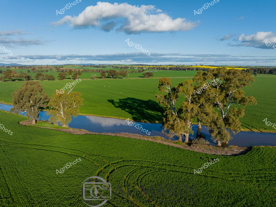
A verdant agricultural landscape unfurls across the golden plains of New South Wales, where emerald green wheat fields stretch to the horizon, interrupted by a sinuous blue creek lined with majestic eucalyptus trees. The mid-morning light casts long shadows from the gnarled river red gums, their silvery-green foliage contrasting against the rich, meticulously planted crop rows that curve and bend with the natural contours of the land. A distant patch of vibrant yellow - likely a canola field - adds a splash of color to the expansive green tapestry, while fluffy white clouds drift lazily across a cerulean sky, suggesting perfect growing conditions for this bountiful agricultural terrain. The creek meanders through the farmland, its reflective surface mirroring the surrounding trees and providing critical water resources for the agricultural ecosystem. Precision farming is evident in the perfectly tracked crop lines, revealing the sophisticated agricultural techniques employed in this region. This panoramic view captures the essence of Australian agricultural excellence - a harmonious blend of natural beauty and human cultivation, showcasing the skill and dedication of farmers who transform these vast landscapes into productive, life-sustaining fields.
 Video
Video
Turbulent waters swirl and bubble around a rocky creek bed, capturing the dynamic energy of a pristine riparian zone in New England, New South Wales. Crystal-clear water cascades over dark, weathered stones, creating a mesmerizing pattern of foam and liquid motion. Tufts of native grasses line the creek's edge, their pale golden-brown strands providing a soft contrast to the churning water's silvery-gray tones. The scene epitomizes the delicate ecological balance of regenerative farming landscapes, where water systems are carefully preserved and protected. Sunlight filters through the moving water, creating a shimmering effect that highlights the natural textures and fluid dynamics of this pristine waterway. The raw, unfiltered video capture speaks to the intricate environmental stewardship practiced in the New England region's agricultural landscapes.
 Video
Video
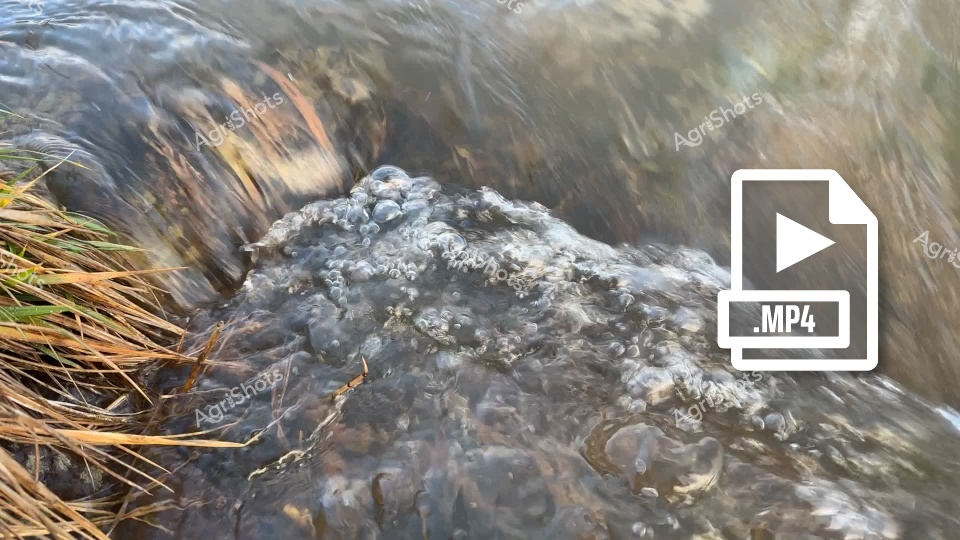
Winter runoff cascades through a rocky creek bed in the New England Tableland region of New South Wales, revealing the dynamic hydrology of a regenerative agricultural landscape. Cool, slate-gray waters surge between weathered basalt boulders, carving intricate pathways through stands of dormant native grasses and sedges. The riparian zone demonstrates the critical ecological interface between water systems and pastoral lands, where careful land management protects soil integrity and water quality. Tufts of pale brown grass emerge from the stream's edges, their resilient stalks bending with the current's momentum, illustrating the adaptive nature of indigenous vegetation in harsh seasonal conditions. The raw, unfiltered MP4 video format suggests a documentary approach to capturing the subtle yet powerful environmental processes that underpin sustainable farming practices. This scene embodies the delicate balance of water, stone, and vegetation that characterizes the sophisticated ecological systems of Australia's high country agricultural regions.
 Image
Image
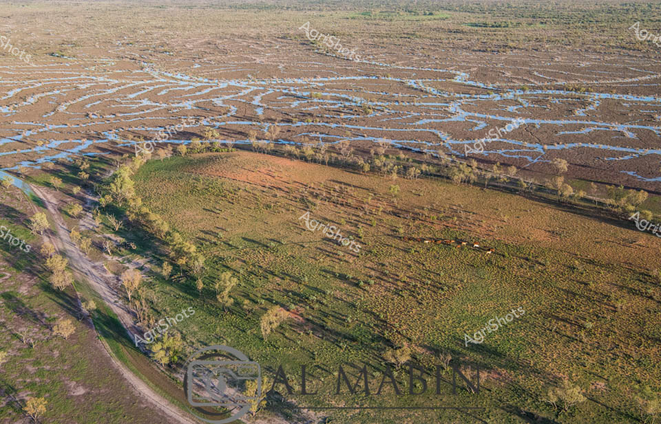
Aerial panorama of Channel Country in western Queensland during flood season, where intricate blue waterways weave across the ochre landscape like delicate capillaries. Lush green pastures curve alongside serpentine water channels, creating a mesmerizing natural tapestry that epitomizes the dynamic ecosystem of Australia's inland pastoral regions. Sparse eucalyptus trees punctuate the floodplain, their silvery-green foliage providing subtle texture against the expansive brown and blue terrain. This extraordinary vista captures the resilience of beef cattle stations during seasonal inundation, where strategic water management transforms seemingly arid landscapes into temporary aquatic networks that nourish grasslands and sustain livestock production. The image reveals the breathtaking scale of Queensland's remote agricultural frontiers, where water becomes a transformative force reshaping the terrain and supporting complex ecological systems. Golden morning light bathes the landscape, highlighting the nuanced topographical details of this remarkable inland watershed.
 Image
Image
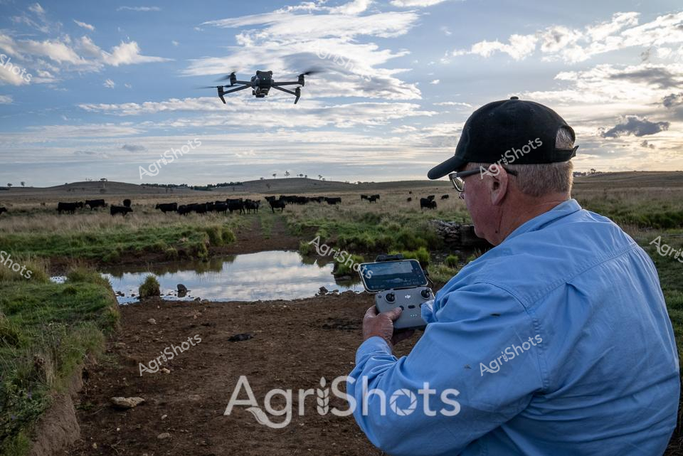
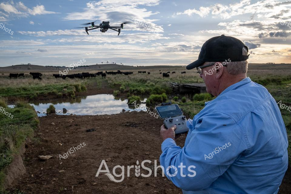
Beneath an expansive New England sky, a seasoned cattleman pilots a drone above his Angus herd, surveying the verdant pastures. The late afternoon light casts long shadows across the undulating landscape, where black cattle graze near a tranquil creek lined with soft green vegetation. Wearing a dark cap and blue workshirt, the experienced farmer manipulates the drone's controls with practiced ease, using cutting-edge technology to monitor his livestock. The scene captures the intersection of traditional agriculture and modern innovation, with the sleek drone hovering above the timeless rural setting. Weathered earth, reflective water, and scattered stones create a textural foreground, while the distant hills and cloud-strewn sky provide a dramatic backdrop to this moment of agricultural precision. The image embodies the spirit of contemporary Australian farming - adaptive, technologically savvy, and deeply connected to the land.
 Video
Video
This video footage captures an extraordinary aerial perspective of a dry, cracked landscape, revealing intricate natural patterns resembling a complex network of dried waterways or eroded soil channels. The video clip showcases an expansive terrain with winding, interconnected lines in varying shades of beige and subtle green, creating a mesmerizing topographical texture that highlights the harsh environmental conditions. The footage appears to document a drought-affected agricultural landscape, likely in an arid or semi-arid region of Australia. The intricate network of cracks and channels suggests prolonged water scarcity, with the ground's surface displaying a fragmented, almost arterial pattern of dried earth. Some of the channels have a slight greenish tinge, indicating minimal vegetation or mineral deposits within the cracked terrain. The color palette is predominantly neutral - soft browns, tans, and muted greens - which emphasizes the parched, weathered nature of the landscape. The video seems to be shot from a high vantage point, possibly using drone technology, which allows viewers to appreciate the full complexity and scale of the environmental conditions. This compelling footage provides a stark visual representation of the challenges faced by Australian agricultural regions during periods of significant drought, illustrating the profound impact of water scarcity on land surfaces.
 Image
Image
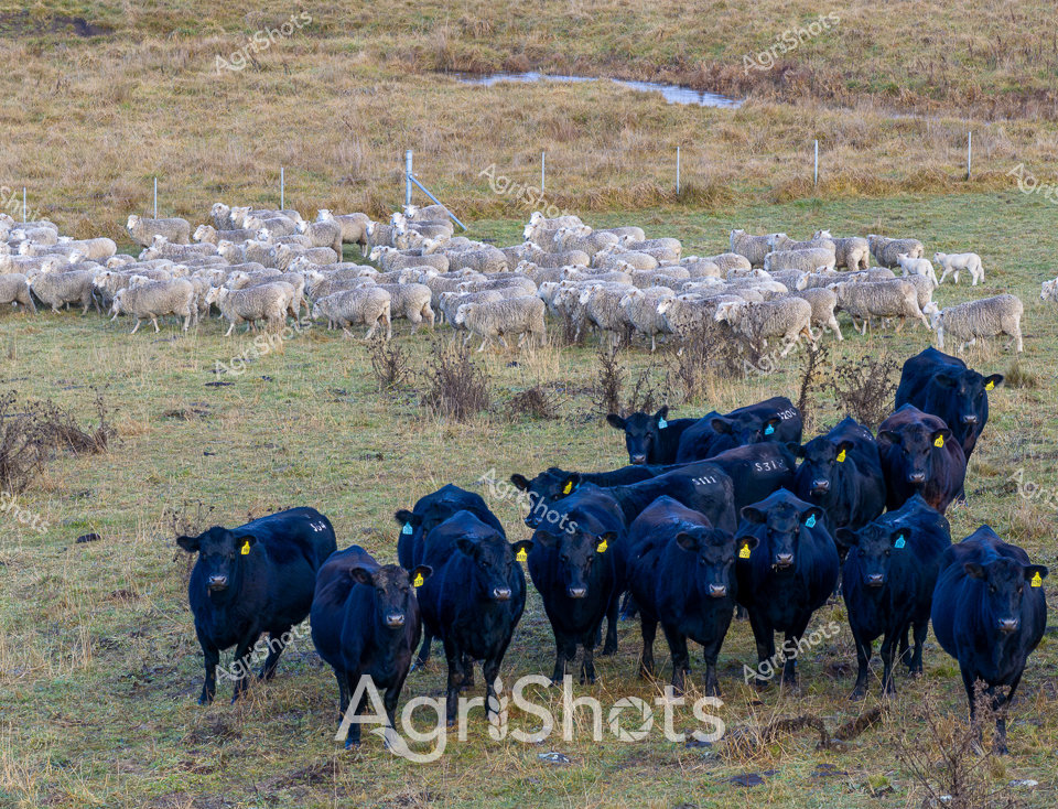
Midnight-blue Angus cattle cluster together on the windswept pastures of New England, New South Wales, their deep ebony coats contrasting sharply against the muted winter landscape. Clustered in the foreground, the herd wears distinctive yellow ear tags, signaling their status as carefully managed stud stock. Behind them, a flock of woolly white sheep grazes near an exclusion-fenced waterway, demonstrating regenerative farming practices that protect riparian zones and water resources. The grasslands appear weathered and sparse, typical of the region's cool winter season, with scattered small shrubs and a distant creek line threading through the undulating terrain. Each animal stands with a quiet intensity, their muscular frames and alert postures reflecting the robust genetics of this agricultural landscape. The yellow identification tags and carefully managed fencing reveal a sophisticated approach to livestock management, where environmental stewardship and genetic quality intersect. This scene captures the essence of New England's agricultural heritage - a landscape of subtle beauty where traditional farming wisdom meets modern conservation practices, creating a harmonious tableau of livestock, land, and careful husbandry.
 Image
Image
Expansive pastoral landscape of the New England region unfolds in muted winter tones, where a carefully managed waterway reveals the principles of regenerative farming. A robust herd of black Angus cattle clusters near a fenced creek, their deep midnight-black coats contrasting against the pale golden grasses and soft green pastures. Interspersed with the cattle, a flock of white sheep grazes peacefully, demonstrating a harmonious multi-species approach to land management. The strategic exclusion fencing along the riparian zone protects the waterway's delicate ecosystem, preventing soil erosion and allowing natural vegetation regeneration. Distant trees punctuate the horizon, creating a sense of depth and showcasing the broad, undulating agricultural landscape of New South Wales. This scene epitomizes sustainable agricultural practices, where livestock and landscape are managed with precision and environmental consciousness, highlighting the sophisticated approach of modern Australian farming.
 Image
Image
Serpentine channels of milky-tan water wind through the parched ochre landscape of Channel Country, revealing the lifeblood of this remote Queensland pastoral ecosystem. A network of ephemeral waterways branches across the arid terrain, lined with resilient remnant trees clinging to the saturated banks during a rare flooding event. The aerial perspective captures the intricate hydraulic arteries that define this harsh yet dynamic agricultural landscape, where water transforms the dusty expanses into a temporary network of life-sustaining corridors. Sparse vegetation and weathered earth tones dominate the scene, punctuated by the sinuous, almost organic flow of water that reflects the region's extreme seasonal variations. This is the raw, unfiltered essence of Australian beef station hydrology - a delicate dance between aridity and sudden abundance, where every drop of water represents survival and potential for pastoral enterprise. The Al Mabbit watermark subtly anchors this remarkable documentation of Australia's inland water systems, a critical resource for livestock and agricultural sustainability.
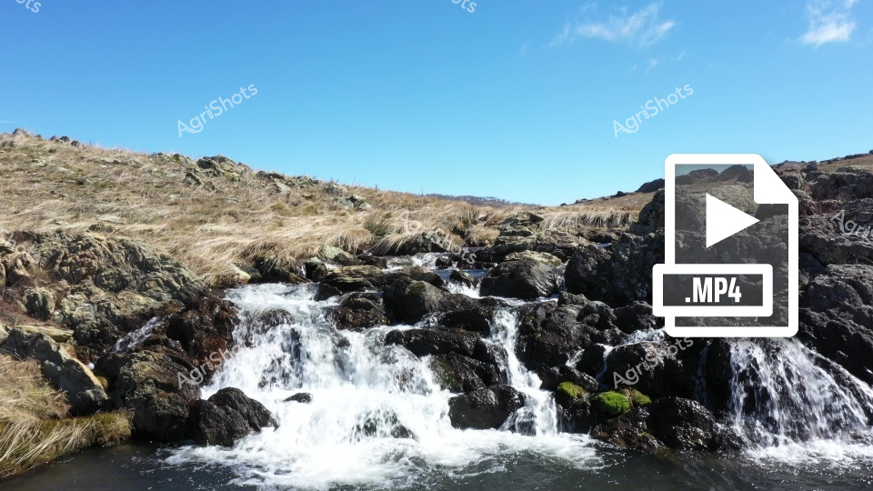 Video
Video
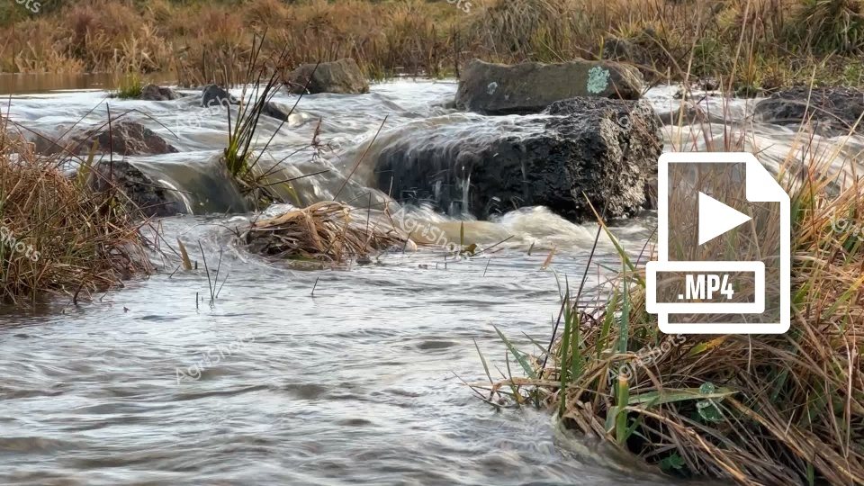
Cascading waters tumble through a rugged rocky landscape, capturing the raw, untamed beauty of a New South Wales mountain creek. Weathered black basalt stones create a natural staircase for the white-foamed water, with tufts of golden-brown grasses clinging to the rocky terrain in the background. The scene breathes with the wild energy of an isolated Australian landscape, where water finds its path through ancient volcanic rock formations. Sunlight bathes the scene in a crisp, clear brilliance, highlighting the contrast between the dark, moss-spotted stones and the brilliant blue sky overhead. A subtle MP4 icon suggests this moment of natural dynamism has been captured in motion, ready to transport viewers to this remote and stunning wilderness. The landscape speaks of endurance - water flowing persistently over immovable stone, a metaphor for the resilience of Australia's rural and natural environments.
 Image
Image
Meandering through the expansive Channel Country of Queensland, a serpentine waterway cuts a vibrant path across the golden-brown grasslands, breathing life into the arid landscape. A small herd of robust beef cattle graze near the water's edge, their rich brown coats contrasting against the sun-bleached pastures, embodying the resilience of Australian livestock in this challenging environment. The winding creek, likely swollen from seasonal flooding, creates a lifeline through the seemingly endless horizon, its banks lined with subtle hints of green vegetation marking the water's influence. The aerial perspective reveals the magnificent scale of this remote pastoral setting, where the sky stretches endlessly in soft blue hues dotted with wispy clouds. The landscape speaks to the harsh yet beautiful nature of outback Queensland, where survival depends on strategic water management and adaptable cattle breeds. The subtle watermark of "Al Mabin" suggests this is a carefully captured moment documenting the agricultural heritage of the region, highlighting the intricate relationship between land, water, and livestock in one of Australia's most challenging agricultural frontiers.
 Image
Image
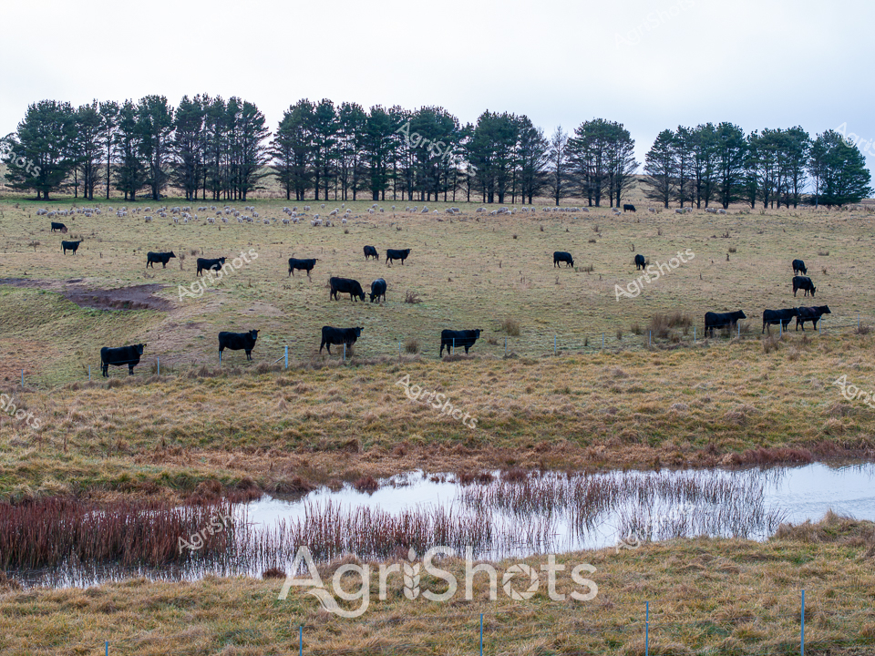
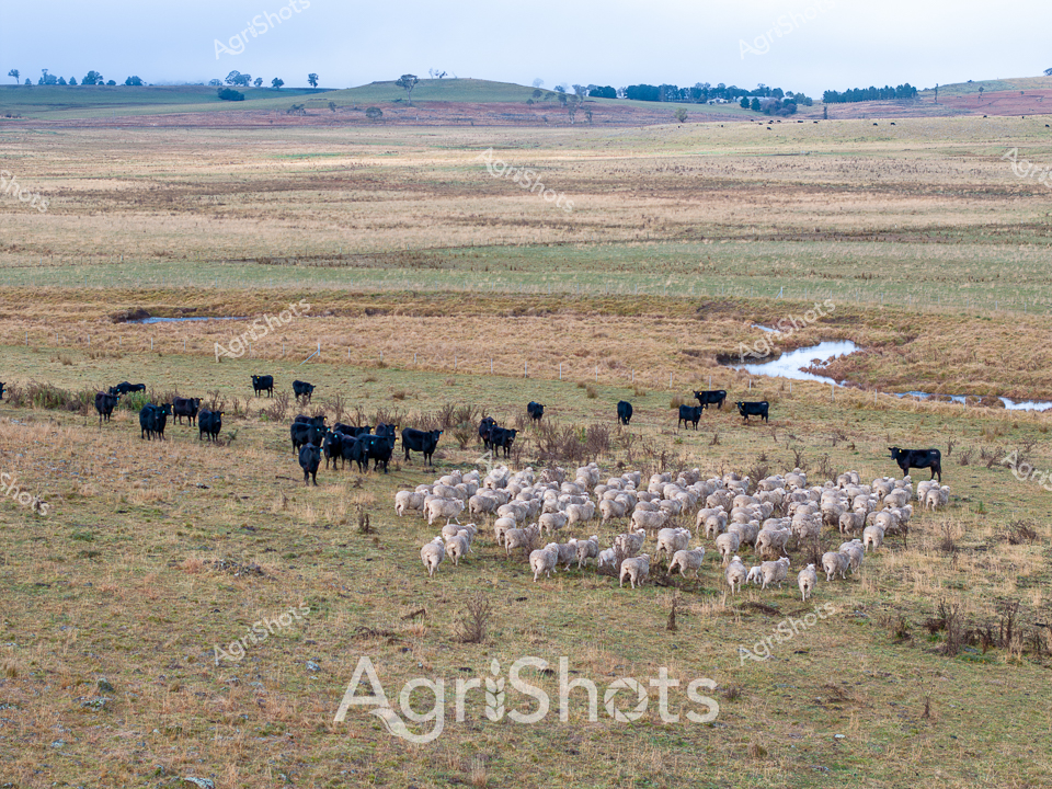
Windswept winter pastures of New England stretch across the New South Wales high country, where a carefully managed agricultural landscape unfolds. A robust herd of black Angus cattle stands sentinel alongside a dense flock of merino sheep, grazing near a meandering creek lined with subtle regenerative farming infrastructure. The riparian zone demonstrates sustainable land management practices, with strategic exclusion fencing protecting the watercourse while allowing controlled livestock access. Soft greys, browns, and muted greens characterize the winter palette, reflecting the austere beauty of this agricultural ecosystem. The livestock cluster near the water, their dark and light forms creating a striking contrast against the undulating paddock, with distant hills and scattered trees forming a classic Australian rural backdrop. This scene captures the essence of progressive pastoral farming - where animal husbandry, environmental stewardship, and landscape conservation converge in a delicate, productive balance.
 Image
Image
Liquid silver rivers fracture the dark earth at dawn, tracing delicate tendrils across the expansive Channel Country landscape near Windorah, Queensland. The aerial perspective captures the mesmerizing hydrology of a flooding waterway, its braided channels gleaming like mercury against the charcoal-dark floodplains as the first golden light crests the horizon. Each sinuous waterline reflects the sunrise, creating an intricate network of luminescent veins that pulse across the arid landscape, revealing the extraordinary natural irrigation patterns of this remote beef cattle station. The intricate water channels speak to the resilience and dynamic nature of Australia's inland ecosystems, where ephemeral rivers transform barren ground into potential pastureland during seasonal floods. Soft gradients of amber and slate stretch to the distant horizon, capturing the raw, elemental beauty of Queensland's remote inland regions. This breathtaking landscape represents the lifeblood of pastoral Australia - water, transforming marginal lands into productive agricultural environments.
 Image
Image
Serpentine waterways of rust-red earth and golden-green vegetation weave across a quintessential Channel Country landscape near Windorah in remote Queensland. Aerial photography reveals the intricate braided patterns of seasonal creek systems, where floodwaters have carved delicate networks across the arid station country. Rich ochre soils contrast beautifully with sparse vegetation, highlighting the extraordinary natural hydrology of this challenging agricultural terrain. The landscape speaks to the resilience of pastoral ecosystems, where water transforms barren ground into a complex tapestry of life during rare flooding events. Geological and ecological processes are captured in stunning detail, showing how water dynamically reshapes this harsh yet breathtaking Australian outback environment. The Al Mabin watermark signifies this as a premium agricultural landscape documentation, capturing the nuanced beauty of Queensland's remote cattle station regions.
 Image
Image
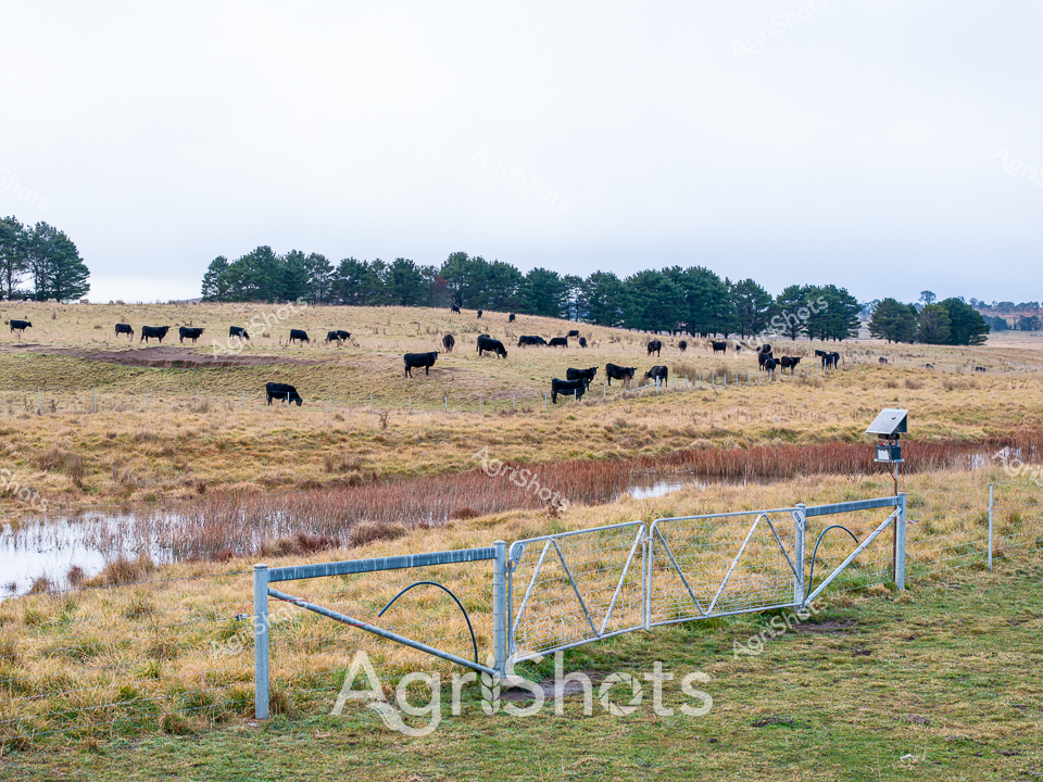
Rural Irrigation Infrastructure in the New South Wales Highlands A weathered concrete water control structure bridges a tranquil creek, nestled among lush tussock grasses characteristic of the high country pastoral landscape. Brilliant blue skies with soft, billowing clouds create a luminous backdrop for this essential agricultural infrastructure, highlighting the strategic water management critical to beef cattle operations in the region. The stone-gray sluice gate stands resilient against verdant grass banks, demonstrating the careful engineering that enables farmers to control water flow and sustain livestock grazing environments. Clear, reflective water moves gently through the channel, symbolizing the lifeblood of agricultural sustainability in this rugged New South Wales highland terrain. The precise alignment of the water control structure reveals generations of farming knowledge embedded in landscape design, where functionality meets the natural contours of the land. This scene captures the quiet, methodical essence of rural infrastructure - a testament to agricultural adaptation and stewardship of the Australian pastoral ecosystem.
 Video
Video
Turbulent creek waters surge and swirl over rocky terrain, capturing the raw energy of a regenerative farming landscape in New South Wales' New England region. Mineral-rich stones emerge from the churning waters, their weathered surfaces glistening with moisture and reflecting the dynamic hydrology of a healthy riparian zone. Blurred motion in the background suggests the constant movement of water, highlighting the critical role of natural waterways in sustainable agricultural ecosystems. The image pulses with a sense of renewal and ecological balance, where water interacts intimately with the geological foundations of the landscape. Soft earth tones of grey, brown, and white blend together, creating a textural canvas that speaks to the interconnectedness of land and water in this agricultural environment. The MP4 icon suggests this is a dynamic video capture, emphasizing the living, breathing nature of this critical agricultural watershed.
 Image
Image
Midnight-black Angus cattle graze across a frost-touched winter pasture in New England's high country, their dark silhouettes contrasting against golden grasses and distant pine windbreaks. A sophisticated riparian management system demonstrates regenerative agricultural practices, with a robust galvanized steel exclusion fence carefully delineating a meandering creek line and protecting sensitive waterway ecosystems. Soft grey light suggests early morning, with delicate winter conditions highlighting the resilience of both livestock and landscape. The meticulously maintained paddock reveals strategic land management, where cattle movement and water conservation intersect through thoughtful environmental stewardship. Russet-hued reed beds border the water channel, adding textural complexity to the scene and indicating careful sustainable farming techniques characteristic of progressive New South Wales agricultural enterprises. This image captures the harmonious relationship between modern farming innovation and the timeless rhythms of rural pastoral landscapes.
 Image
Image
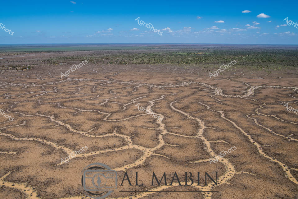
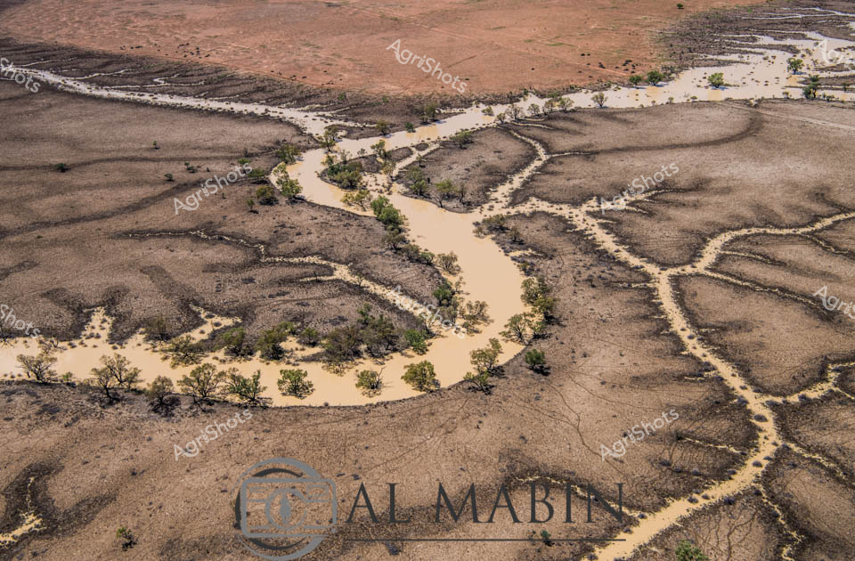
Expansive Channel Country floodplain stretches toward the distant horizon, revealing the raw beauty of Queensland's interior landscape. A sinuous dry creek bed meanders across the sun-drenched terrain, its pale sandy path cutting through muted earth tones of brown and subtle green. Intermittent patches of bright green vegetation suggest recent rainfall has brought fleeting life to this arid pastoral region, highlighting the delicate ecological balance of Australia's inland stations. The wide blue sky, populated with soft white clouds, creates a sense of immense openness and potential, characteristic of the vast beef production areas of western Queensland. The watermark of Al Mabin, a renowned agricultural photographer, anchors the image, signaling this as a professional documentation of the challenging and beautiful landscapes that sustain Australia's cattle industry. The composition captures the resilience of the landscape - a network of natural watercourses waiting to be activated by seasonal floods, ready to transform this seemingly dormant terrain into a momentary oasis of pastoral productivity.
 Image
Image
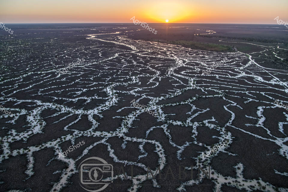
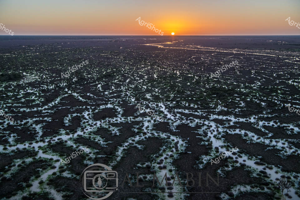
Golden Dawn over Channel Country Floodplains Sunrise bathes the expansive Channel Country landscape in ethereal light, revealing the intricate network of braided waterways and flooded grasslands characteristic of Queensland's remote western regions. Dark earth and silvery water intertwine in complex, vein-like patterns stretching to the horizon, creating a mesmerizing topographical tapestry that speaks to the dynamic hydrology of Australia's inland river systems. The early morning sun emerges as a perfect golden orb, casting warm amber and orange hues across a flat, seemingly infinite landscape that epitomizes the raw, elemental beauty of outback Australia. These seasonal floods are crucial for regenerating pastures, supporting livestock grazing, and maintaining the delicate ecological balance of this arid agricultural zone. The image captures the precise moment when dawn transforms the landscape, illuminating the water-saturated terrain with a luminous, almost ethereal quality that highlights the resilience and adaptability of pastoral ecosystems. This aerial perspective reveals the sublime complexity of Australia's inland waterways, where water is both a precious resource and a transformative environmental force.
 Image
Image
An aerial view reveals the intricate, serpentine waterways of Channel Country in Queensland, where dry creek beds and floodplains create a mesmerizing network of sinuous lines across the arid landscape. The branching water channels, etched into the dusty earth, showcase the complex hydrology of this remote Australian region, highlighting the resilient geography that supports pastoral activities during seasonal flooding. Green vegetation clusters along the horizon, contrasting with the golden-brown tones of the expansive, water-carved terrain.
 Image
Image
In the soft light of a spring dawn, a seasoned cattle manager pilots a drone across a New England region pasture in New South Wales, surveying a herd of black Angus cattle grazing near a tranquil creek. Wearing a blue long-sleeved shirt and black cap, the operator stands with his back to the camera, carefully navigating the drone's flight path using a handheld controller. The landscape unfolds in muted earth tones - rich brown soil, verdant grass patches, and a reflective water surface mirroring the dynamic cloud-strewn sky. A cluster of sturdy Angus cattle, their deep black coats gleaming, move slowly across the undulating grasslands, creating a living tableau of pastoral Australia. The drone hovers with precision, representing the increasing integration of advanced technology in modern agricultural management, allowing for efficient and detailed livestock monitoring. This scene captures the essence of contemporary agricultural practice - where traditional farming wisdom meets cutting-edge technological innovation, seamlessly blending human expertise with sophisticated aerial surveillance.
 Image
Image
Meandering waterways carve intricate golden-edged channels across the parched earth of Queensland's Channel Country, revealing the dramatic hydrology of Australia's arid interior. Delicate ribbons of yellowed vegetation trace the ephemeral creek lines, highlighting the complex networks that carry precious water across this harsh landscape during rare flooding events. The aerial perspective transforms the landscape into an abstract topographical map, showcasing the resilient ecological patterns of inland Australia's beef station territories. Windorah's distinctive landscape emerges as a masterpiece of natural engineering, where water navigates through sun-baked terrain in serpentine patterns that speak to the region's extreme environmental conditions. These seasonal water flows are lifelines for remote pastoral operations, providing critical hydration for livestock and sustaining sparse vegetation in one of the continent's most challenging agricultural environments. The muted browns and subtle golden highlights capture the raw beauty of Queensland's inland watersheds, illustrating the delicate balance of survival in Australia's unforgiving outback.
 Image
Image
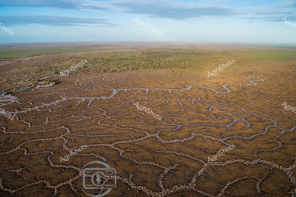
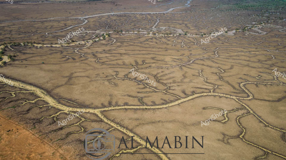
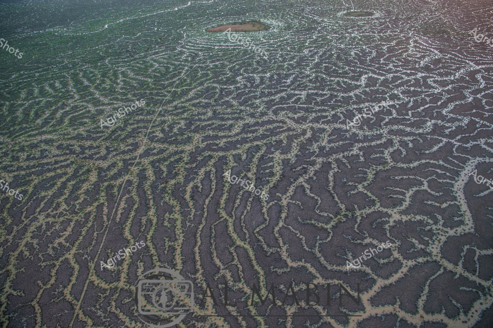
This aerial image captures an intricate network of waterways and channels winding through arid terrain, typical of Queensland's Channel Country. Sandy-colored water pathways snake between dark earth and sparse vegetation, creating a complex, maze-like pattern that reveals the dynamic hydrology of this remote landscape. The natural water distribution system demonstrates the resilient ecosystem of Australia's inland regions, with intermittent vegetation highlighting the delicate balance of water and land in this harsh environment.
 Image
Image
Aerial view of Al Mabin's Channel Country, revealing the intricate network of ephemeral waterways that define this remarkable Queensland landscape. Serpentine channels of pale sand weave through dark earth, creating a mesmerizing natural pattern that resembles delicate river veins across the arid terrain. Sparse vegetation of muted yellows and greens punctuates the landscape, highlighting the resilience of life in this harsh environment. The waterways, etched by seasonal floods, showcase the dynamic hydrology of Australia's inland river systems, where water becomes a transformative force shaping the landscape. These braided channels are critical to the survival of beef cattle stations, providing essential water resources and creating unique grazing corridors in the remote outback. The image captures the raw, elemental beauty of Queensland's remote interior, where water's intermittent presence sculpts a living, breathing geographical masterpiece.
 Image
Image
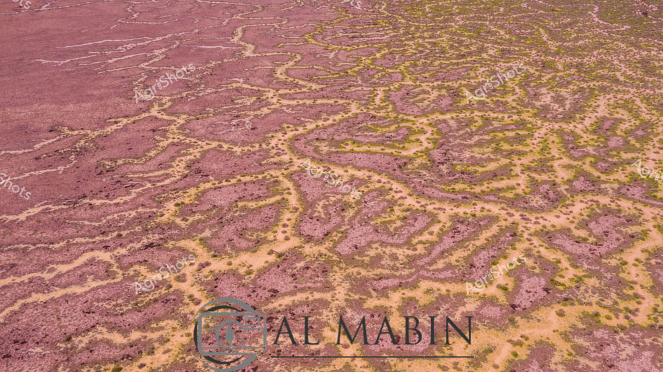
Aerial view of intricate water channels spreading across an arid Queensland landscape, capturing the mesmerizing patterns of flood irrigation in Channel Country. Sinuous lines of water weave through dark and green-tinted earth, creating a natural labyrinth that resembles delicate veins across the barren terrain. The complex network of waterways reveals the transformative power of seasonal flooding, where ephemeral rivers and creeks spread nutrients and moisture across the harsh outback landscape. Subtle gradients of green, brown, and grey blend together, showcasing the delicate balance of water management in Australia's remote beef production regions. This extraordinary perspective highlights the resilience of pastoral landscapes, where strategic water distribution enables livestock grazing in some of the continent's most challenging environments. The image captures the raw beauty of Queensland's inland hydrology, where every water channel represents a lifeline for agricultural survival in an unforgiving ecosystem.
 Image
Image
A serpentine creek winds through an expansive emerald wheat field, carving a sinuous blue path across the lush agricultural landscape of rural New South Wales. Precision farming is evident in the perfectly aligned tractor tracks cutting gentle curves through the vibrant green crop, highlighting the meticulous cultivation of this golden grain-producing region. Distant rolling hills and scattered eucalyptus trees frame the horizon, creating a patchwork of verdant greens and soft earth tones under a dramatic cloudscape of billowing white formations against a clear azure sky. The morning light casts long shadows from a weathered river red gum tree, its gnarled branches reaching over the water, symbolizing the enduring relationship between water, land, and agricultural prosperity. This aerial perspective captures the essence of Australian broadacre farming - a harmonious blend of natural beauty and human agricultural engineering, where every contour and waterway plays a crucial role in the production of wheat that will feed communities across the continent. The immaculate green field stretches toward the horizon, a testament to the careful management and technological sophistication of modern Australian agriculture.
 Image
Image
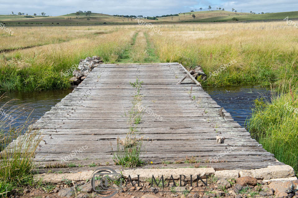
Weathered timber bridge spans a gentle creek, bisecting golden grasslands of a quintessential NSW rural landscape. Aged wooden planks, silvered by decades of sun and rain, create a rustic crossing point through lush pastures dotted with scattered eucalyptus trees on distant rolling hills. Soft green grass sprouts between the bridge's weathered boards, suggesting periodic flooding and regenerative cycles typical of Australian pastoral regions. The subdued palette of wheat-colored grasses, blue-grey creek waters, and muted sky creates a serene tableau of agricultural sustainability. This pastoral scene epitomizes the resilient infrastructure of cattle country, where simple yet robust crossings enable livestock movement and farm management across undulating terrain. The bridge represents a quiet testament to generational agricultural practice - functional, enduring, and harmoniously integrated with the natural landscape.
 Video
Video
Merino sheep cluster tightly together on a sun-drenched hillside, their dense woolly coats creating a uniform sea of creamy white against the vibrant turquoise sky. A lone, weathered tree stands sentinel over the flock, its sparse branches casting a subtle shadow on the densely packed animals. The landscape reveals a classic Australian pastoral scene - rich brown earth transitioning to patchy green grasslands, suggesting late summer or early autumn in rural New South Wales. These carefully managed Merino sheep demonstrate the precision of Australian livestock farming, packed into a compact group that speaks to expert mustering techniques. The MP4 video icon suggests this is a raw, unedited capture of pastoral life, providing an authentic glimpse into the rhythms of agricultural work. The image captures the essence of Australian sheep farming - resilience, tight community, and the stark beauty of agricultural landscapes where livestock and environment exist in delicate balance.
 Video
Video
Crystalline droplets cascade over smooth river stones, capturing the essence of a pristine riparian ecosystem in New England's rugged New South Wales landscape. Bubbling water flows dynamically, revealing the intricate textures of a healthy creek environment - a testament to regenerative agricultural practices that preserve natural waterways. Sunlight filters through the moving water, creating a shimmering mosaic of translucent bubbles and gleaming stone surfaces, highlighting the delicate balance between water movement and geological formations. The close-up perspective invites viewers into the microscopic world of a thriving waterway, where each bubble and rocky surface tells a story of ecological interconnectedness. Soft earth tones of brown, gray, and silver blend seamlessly, creating a natural palette that speaks to the untouched beauty of this rural watershed. The MP4 video format suggests a dynamic, living representation of this critical agricultural landscape element, capturing the fluid motion and subtle complexities of water in motion.
 Video
Video
The video footage captures a stark, arid landscape showcasing the harsh realities of drought conditions in rural Australia. The frame reveals a barren, rust-colored terrain with a textured ground that appears cracked and parched, stretching endlessly toward a distant horizon. Subtle variations in the earth's surface create a mosaic of dusty browns and reddish tones, highlighting the extreme dryness of the environment. This clip likely documents the challenging agricultural conditions faced by farmers during extended periods of water scarcity. The landscape seems devoid of vegetation, with only sparse, withered vegetation hinting at the struggle of survival in such an unforgiving climate. The monotone color palette of browns and tans emphasizes the severity of the drought, creating a sense of desolation and environmental stress. The video appears to be shot during what seems to be a winter period, capturing the full impact of prolonged dry conditions in a region likely located in South Australia or another drought-affected area. The ground's texture suggests wind erosion and lack of moisture, with small undulations and scattered rocky patches breaking the otherwise uniform surface. While the scene might appear bleak, it powerfully represents the resilience of Australian agricultural landscapes and the ongoing challenges of farming in extreme environmental conditions. The footage serves as a critical document of climate and agricultural realities.
 Image
Image
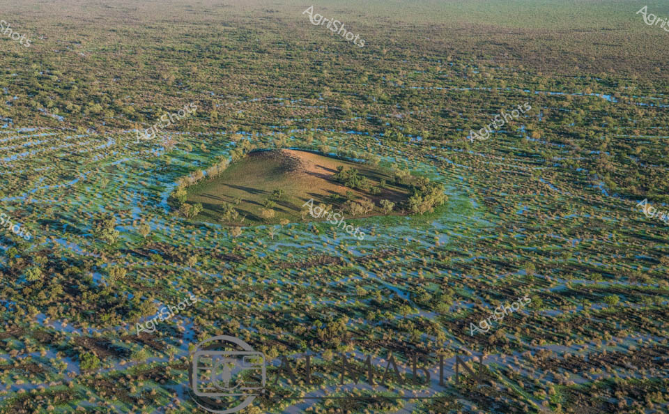
Aerial vista of Channel Country in Queensland during peak flood season, a mesmerizing landscape of interconnected waterways and verdant floodplains stretching to the horizon. A solitary elevated landmass—likely a cattle station's strategic high ground—emerges like an island sanctuary amidst the expansive blue-green aquatic terrain. The intricate network of water channels weaves between sparse vegetation, creating a mosaic of azure and olive hues that characterize this unique Australian inland ecosystem. Seasonal flooding transforms the arid landscape into a dynamic, life-sustaining environment, critical for supporting cattle grazing and native biodiversity in this remote region. The subtle undulations of the terrain reveal the complex hydrology of Channel Country, where water becomes the defining element of survival and agricultural potential. This breathtaking aerial perspective captures the raw, untamed beauty of Queensland's inland waterways, showcasing the resilience and adaptive nature of Australia's agricultural landscapes.
Well, you've ploughed through the whole field!
No more crops to harvest here, mate.
Try searching for something else in our library of 50,000+ royalty-free media: