 Image
Image
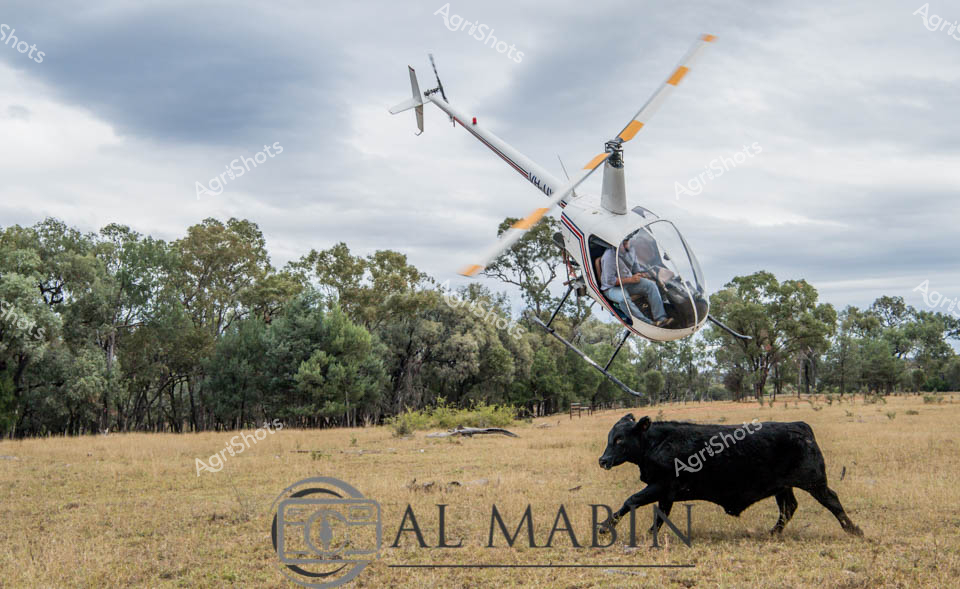
Agricultural mustering operations unfold across a sun-weathered Queensland cattle station, where a nimble white helicopter hovers low over dry pastureland, herding a powerful black Angus bovine. The lightweight aircraft, with its transparent cockpit and precision rotors, demonstrates the modern technological approach to livestock management in Australia's expansive rural landscapes. Surrounding eucalyptus and olive-green trees frame the rugged terrain, reflecting the harsh yet beautiful environmental conditions of outback cattle country. The sleek black beast moves purposefully across the golden-brown grassland, embodying the resilience of breeding stock carefully managed through aerial techniques. Al Mabtin's watermark suggests this is a professional documentation of contemporary agricultural practice, capturing the dynamic interaction between advanced aviation and traditional cattle farming. The overcast sky and muted landscape colors underscore the practical, no-nonsense approach of Queensland's cattle industry, where efficiency and skill combine to manage livestock across vast, challenging territories.
 Image
Image
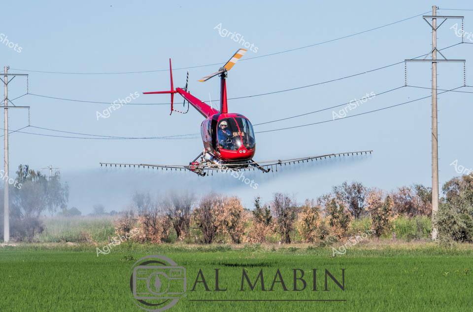
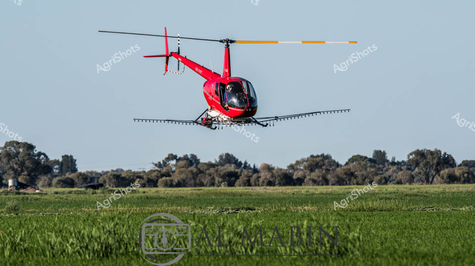
Precision agricultural aviation transforms the verdant rice fields of the Riverina. A vibrant crimson Robinson R44 helicopter hovers mere meters above the lush green crop, its extended spray boom dispersing a fine agricultural mist across the meticulously cultivated landscape. Electricity transmission towers punctuate the soft blue horizon, framing the agricultural intervention with industrial infrastructure. The helicopter's metallic red fuselage gleams against the soft seasonal light, while its specialized agricultural attachment delivers targeted crop treatment with surgical accuracy. Suspended between power lines and ripening fields, the aircraft represents the pinnacle of modern farming technology - a dynamic fusion of aerial mobility and agricultural science. The misty spray creates a ethereal veil between machine and landscape, capturing the delicate balance of technological intervention and natural growth in the fertile agricultural heartland of New South Wales.
 Image
Image
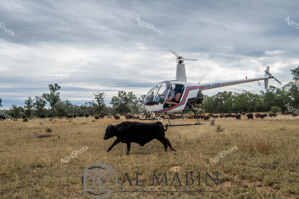
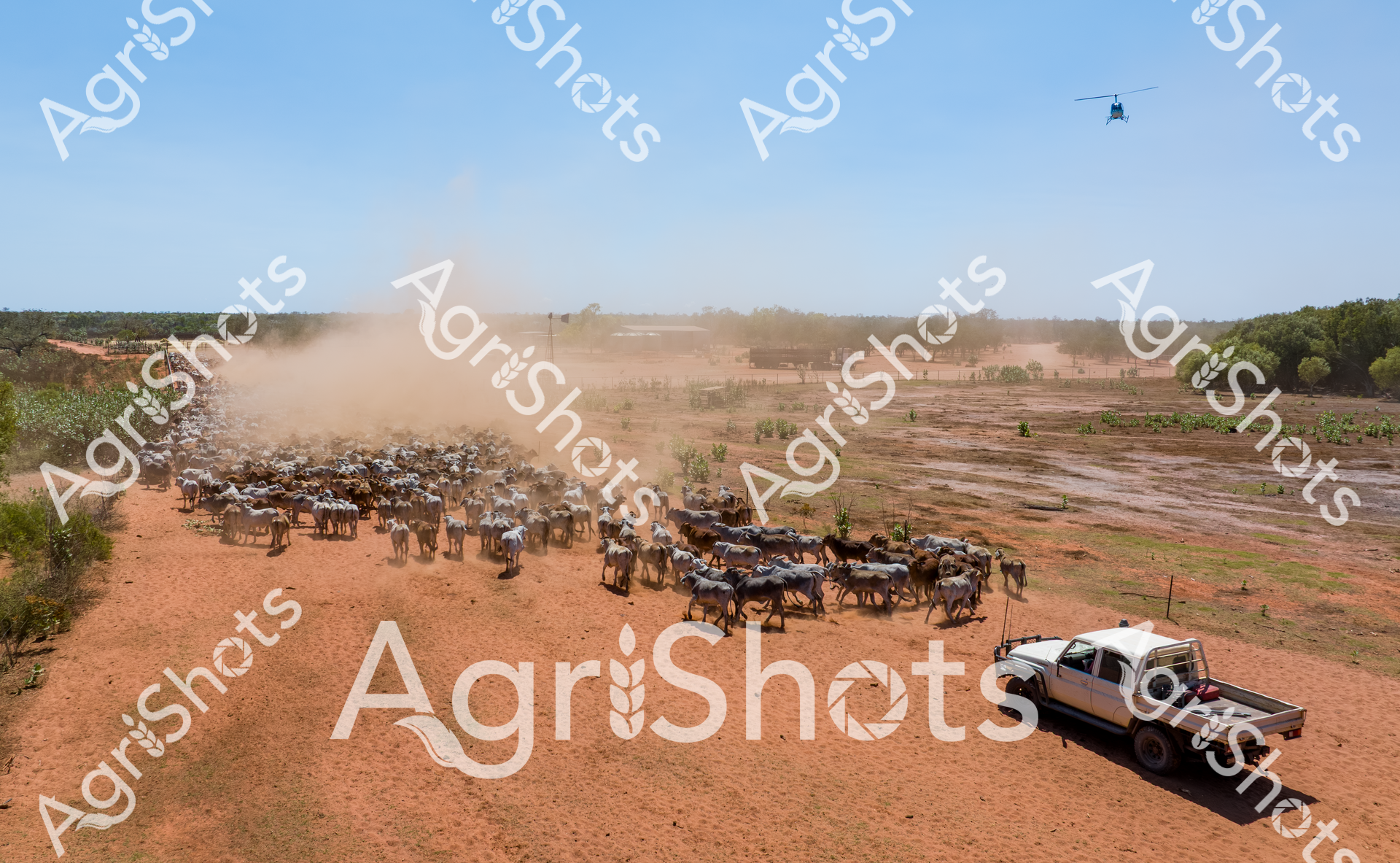
Cattle mustering unfolds across a sun-weathered Queensland pastoral landscape, where a sleek white Robinson R22 helicopter hovers low over a dusty, grass-stubbled paddock. Black Angus cattle move methodically across the dry terrain, their dark hides contrasting against the muted golden grasslands and scattered eucalyptus trees. The helicopter, registration VH-UXM clearly visible, demonstrates precision agricultural aviation techniques used in large-scale cattle management, with a pilot skillfully navigating just meters above the herd. Overcast skies create a moody, dramatic backdrop, highlighting the rugged resilience of Australian cattle station operations. This dynamic scene captures the intricate choreography between modern aviation technology and traditional livestock herding practices, showcasing the sophisticated methods employed in Queensland's beef production industry. The image embodies the spirit of Australian agricultural innovation - where cutting-edge equipment meets vast, unforgiving landscape to manage livestock across expansive stations.
 Video
Video
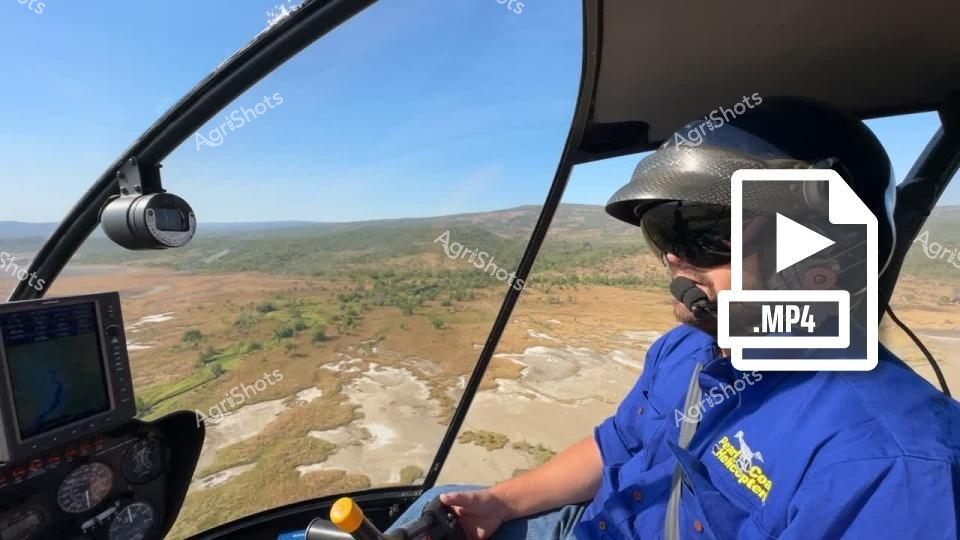
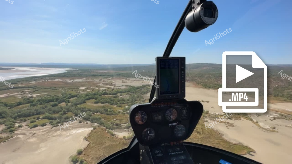
Aerial agricultural survey across the rugged Western Australian landscape, captured from the cockpit of a precision helicopter. A pilot in a vivid blue uniform and protective silver helmet navigates over a sprawling pastoral terrain, revealing the intricate topography of rocky outcrops, sparse woodland, and meandering waterways. The expansive golden-brown terrain stretches beneath the aircraft, punctuated by isolated vegetation clusters and geological formations that speak to the harsh yet beautiful inland regions. Advanced onboard camera technology and navigation instruments suggest a sophisticated approach to modern agricultural monitoring and land management. The crisp blue sky and clear visibility indicate an ideal surveying day, where every contour of the landscape can be meticulously examined from this aerial perspective. This image encapsulates the critical role of aerial reconnaissance in understanding and managing vast agricultural territories in Western Australia's challenging environments.
 Video
Video
Soaring above the vast Western Australian landscape, this raw video frame captures the sweeping panorama of a remote station from a helicopter's cockpit. Dusty riverbanks and scattered green vegetation stretch across the undulating terrain, revealing the rugged beauty of Australia's agricultural heartland. Instrument panels and navigation equipment frame the foreground, offering a pilot's-eye view of the expansive countryside below. Soft blue skies blend with the earthy tones of the landscape, creating a sense of infinite space and untamed wilderness. The winding river cuts through the terrain like a silver ribbon, highlighting the critical water resources that sustain these remote agricultural regions. This aerial perspective provides a breathtaking glimpse into the challenging and majestic environment of Western Australia's pastoral stations, where agriculture and landscape merge in a delicate, powerful balance.
 Image
Image
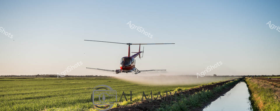
Aerial crop management takes flight in this dynamic agricultural scene from the Riverina region of New South Wales. A vibrant red helicopter hovers low over a lush green crop field, its precision spray boom extended and dispersing a fine mist of agricultural treatment. The early morning light casts a soft blue backdrop, highlighting the intricate agricultural landscape with its carefully cultivated field bordered by an irrigation channel. Suspended between earth and sky, the helicopter represents cutting-edge farming technology, demonstrating the sophisticated methods used by modern Australian agricultural professionals to protect and nurture crops. The controlled spray pattern reveals the calculated expertise of the pilot, maintaining a perfect hover just meters above the verdant field. This image captures the intersection of advanced technology and traditional agricultural practice, showcasing the innovative spirit of Australian farming in the expansive, fertile plains of the Riverina.
 Video
Video
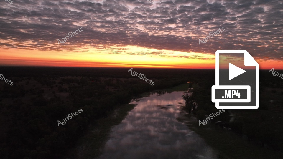
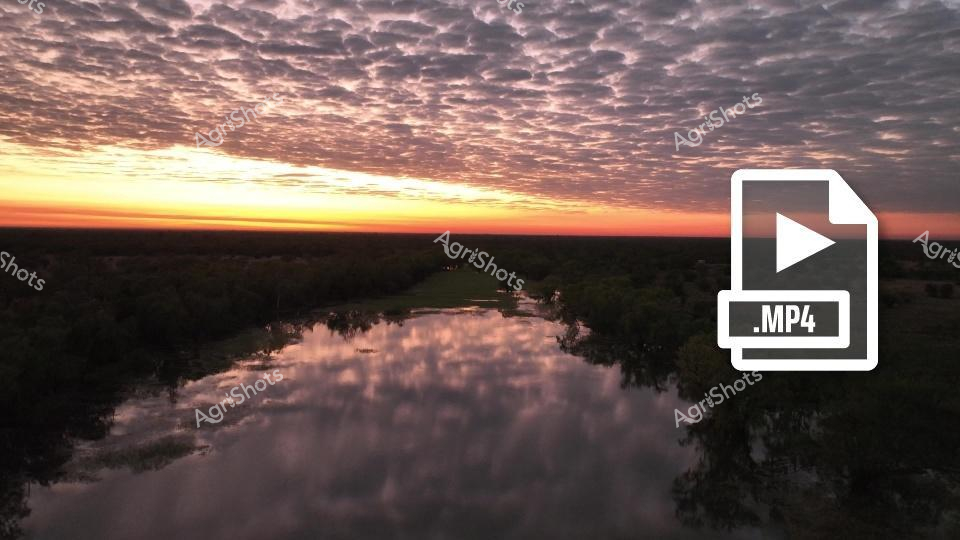
Epic dawn breaks over a winding river, illuminating the vast Western Australian landscape with breathtaking golden and crimson light. Dense, textured clouds blanket the horizon, creating a dramatic aerial panorama that captures the expansive scale of a remote agricultural station. The serpentine waterway reflects the sunrise's luminous colors, meandering through dark silhouetted terrain that stretches toward an infinite horizon. Early morning light transforms the sky into a canvas of burnt oranges, deep purples, and soft yellows, revealing the raw, untamed beauty of the Australian outback. The scene evokes a sense of profound solitude and immense natural grandeur, characteristic of Western Australia's remarkable pastoral regions. A subtle MP4 video icon suggests this stunning landscape is captured in motion, promising a dynamic visual narrative of rural Australian wilderness.
 Image
Image
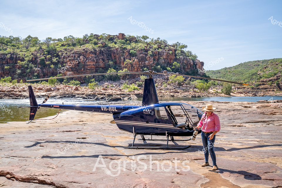
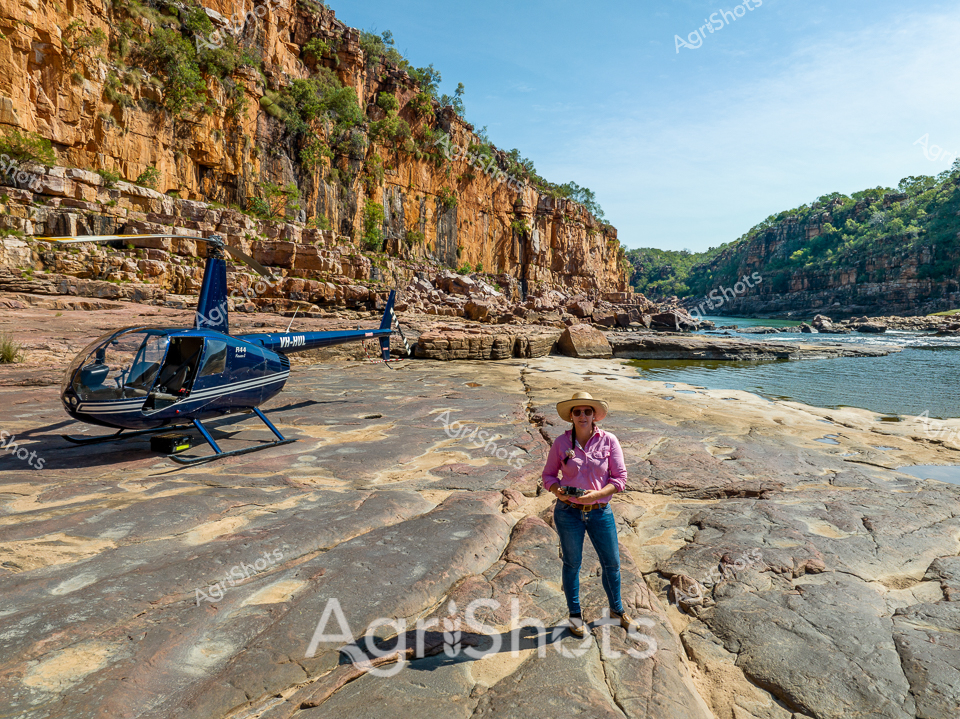
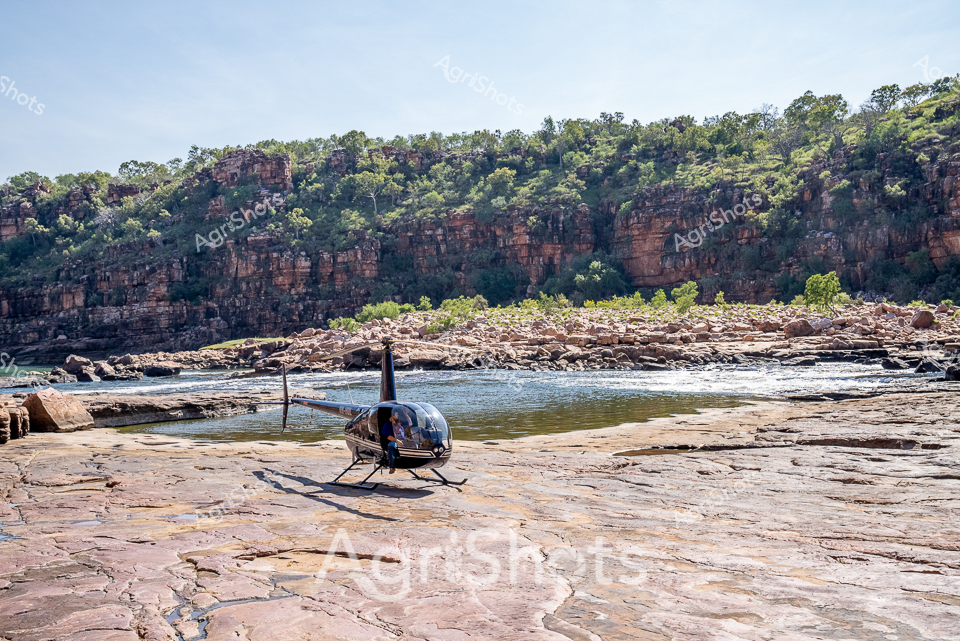
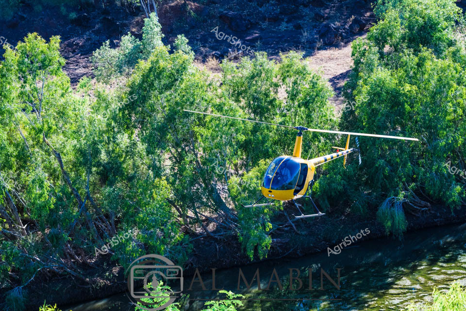
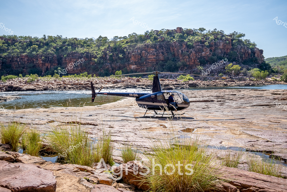
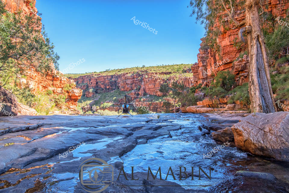
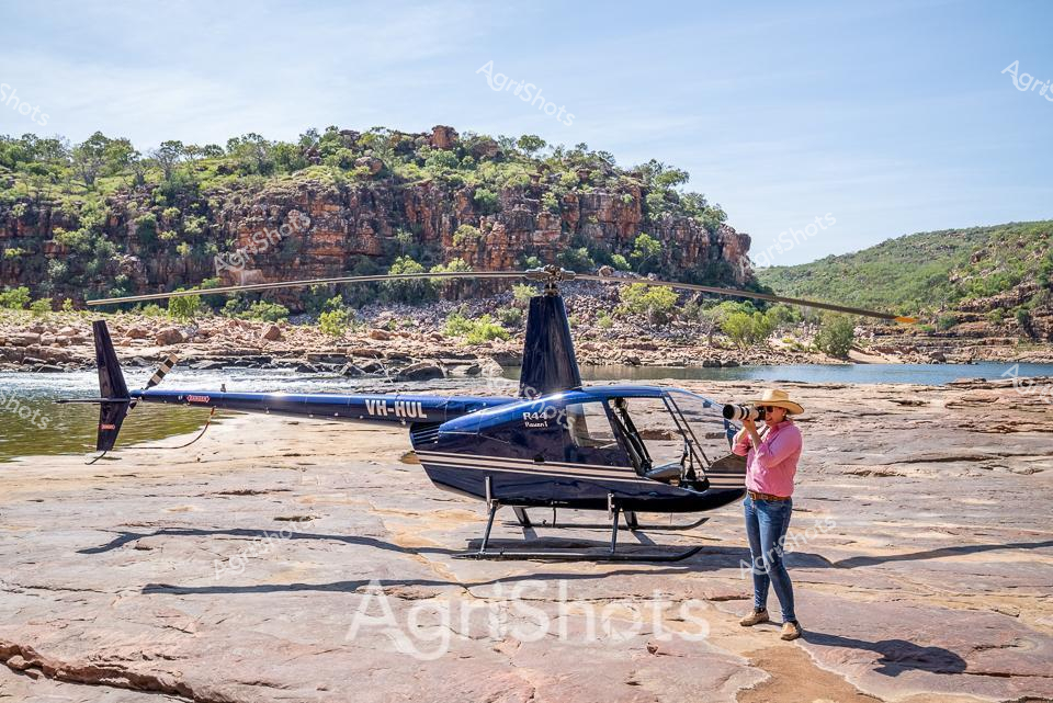
Rugged Katherine Gorge unveils a moment of agricultural adventure as a sleek black Robinson R44 helicopter rests on the sun-baked rock formations of the Nitmiluk National Park. A professional in a vibrant pink long-sleeved shirt and wide-brimmed agricultural sun hat stands nearby, her stance suggesting surveying or reconnaissance work typical of modern pastoral management. The dramatic landscape of layered sandstone cliffs, punctuated by hardy vegetation clinging to rocky outcrops, frames the scene with quintessential Northern Territory wilderness. Rocky riverbed terrain provides a natural landing pad, highlighting the versatility of aerial technology in monitoring vast agricultural landscapes. The clear blue sky and rocky water course speak to the challenging yet beautiful environments Australian farmers and station managers navigate daily. This image captures the intersection of high-tech agricultural practice and timeless landscape - a powerful representation of contemporary rural enterprise in Western Australia's remote regions.
 Image
Image
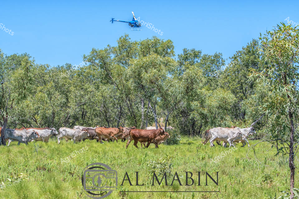
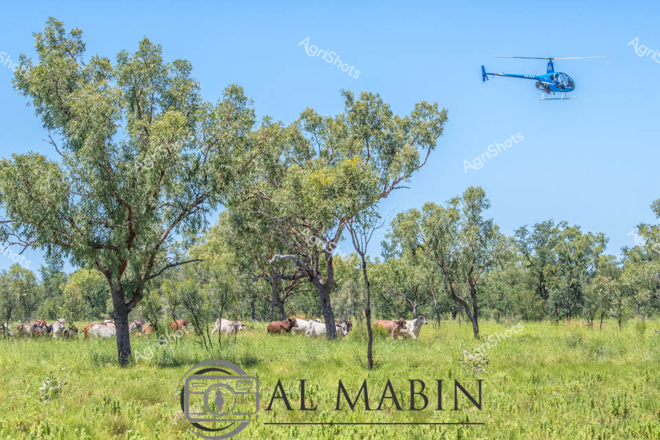
Brahman cattle surge across lush green pastureland beneath a cloudless azure sky, driven by a blue helicopter hovering above the scattered eucalyptus woodland. The herd - a mix of white and russet-colored cattle - moves with purposeful momentum through the sunlit landscape of Western Australia's rugged Kimberley region. Lean and muscular Brahman cattle, renowned for their heat and tick resistance, track across vibrant grasslands dotted with silver-leafed trees, embodying the resilience of northern Australian pastoral operations. The aerial muster captures the dynamic interaction between modern agricultural technology and timeless landscape, with the helicopter providing precision guidance to the moving herd. Al Mabin's watermark signals this as a professional agricultural photography capture, documenting the intricate choreography of cattle management in one of Australia's most challenging and beautiful agricultural terrains. The scene radiates a sense of controlled energy - the cattle moving with disciplined intent, the helicopter maintaining strategic oversight, all set against the untamed beauty of the Kimberley's expansive pastoral backdrop.
 Video
Video
The footage captures a dramatic aerial view of a rugged Australian landscape featuring steep, rust-red rock formations and expansive green plateaus. This video clip showcases the breathtaking topography of what appears to be a remote wilderness region, likely in the Northern Territory or Western Australia's Kimberley region. Massive table-top mountains with sheer cliff faces rise dramatically from a verdant valley floor, creating a stunning geological panorama that highlights the raw, untamed beauty of Australia's interior. The video frame reveals intricate geological details, with deep red rock walls displaying complex layering and erosion patterns contrasting against the lush green vegetation covering the surrounding landscape. Distant mountain ranges create a series of horizontal ridgelines that stretch toward the horizon, suggesting an immense, untouched wilderness. A hint of vegetation grows tenaciously along the rock formations, demonstrating the resilience of life in this harsh yet beautiful environment. The lighting suggests early morning or late afternoon, with soft illumination that accentuates the landscape's textures and creates subtle shadows across the terrain. This cinematic footage captures the essence of Australia's remarkable geological diversity, presenting a landscape that speaks to the ancient, unforgiving beauty of the continent's interior regions.
 Image
Image
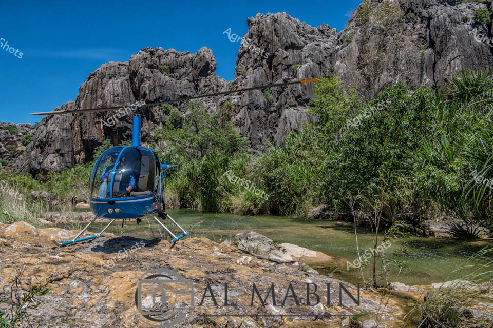
A seasoned agricultural professional surveys the rugged Kimberley landscape, standing confidently on ancient river rock formations near a blue Robinson R44 helicopter. The dramatic geological formations of layered sandstone cliffs rise majestically around a winding river channel, revealing the raw beauty of Western Australia's remote pastoral regions. Wearing a pink work shirt, blue jeans, and a wide-brimmed sun hat, the woman embodies the resilience and adventurous spirit of contemporary agricultural practitioners who navigate challenging terrains to manage vast pastoral estates. The rocky foreground and steep cliff walls suggest this is likely a remote cattle station access point, where aerial reconnaissance is crucial for monitoring extensive landholdings. Bright sunlight illuminates the textured rock surfaces, casting intricate shadows and highlighting the golden-orange and tan geological strata that characterize this stunning northern Australian landscape. The scene captures the intersection of modern agricultural technology and timeless geological grandeur, showcasing how contemporary farmers leverage sophisticated tools like helicopters to manage and understand their expansive territories.
 Video
Video
Slicing through the dense eucalyptus woodland of the Adelaide River region, a nimble blue helicopter hovers low, executing a precise cattle muster in the rugged Northern Territory landscape. Rolling hills draped in silvery-green bushland create a textured backdrop of soft undulations, punctuated by rocky outcrops and scattered patches of reddish earth. The aerial mustering technique, a quintessential strategy in the expansive Northern Territory cattle stations, allows stockmen to efficiently gather and direct Brahman cattle - renowned for their heat tolerance and distinctive humped physique - across the challenging terrain. Autumn's muted light casts a soft haze over the scene, highlighting the strategic movement of the helicopter as it guides livestock with minimal ground disturbance. The raw, unedited video capture epitomizes the dynamic intersection of modern agricultural technology and timeless pastoral traditions, showcasing the skill and innovation required to manage vast cattle holdings in Australia's remote northern landscapes. This compelling visual narrative speaks to the resilience, technological adaptation, and deep connection to land that defines contemporary Australian agricultural practice.
 Image
Image
Brahman cattle graze peacefully beneath silvery-green eucalyptus trees in the expansive Kimberley grasslands of Western Australia, while a blue helicopter hovers overhead, signaling the start of a cattle muster. The robust herd, characterized by their distinctive humped shoulders and light-colored coats, rests in the dappled shade, their calm demeanor contrasting with the imminent movement. Bright green grass carpets the landscape, punctuated by scattered gum trees that provide natural windbreaks and shelter, typical of this rugged northern Australian pastoral terrain. The clear azure sky and crisp lighting suggest mid-morning, with perfect conditions for livestock management operations. The Al Mabin watermark indicates this is a professional agricultural documentation, capturing the essence of large-scale cattle farming in one of Australia's most challenging and beautiful agricultural regions. This scene epitomizes the intricate dance between modern agricultural technology and timeless pastoral traditions, where helicopters have replaced horses in the age-old practice of mustering cattle across vast, untamed landscapes.
 Image
Image
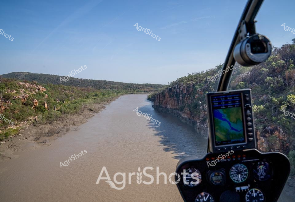
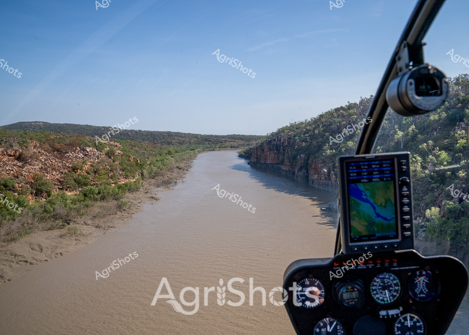
Sweeping through the rugged Kimberley landscape, a helicopter provides an aerial perspective of the dramatic waterway carving through ancient rocky terrain. The muddy river winds between steep stone cliffs adorned with sparse vegetation, revealing the harsh yet beautiful geology of Western Australia's northern region. Instrument panels in the foreground frame the expansive view, with navigation screens displaying topographical details of the surrounding countryside. Rocky outcrops and dense scrubland rise from the riverbanks, showcasing the untamed wilderness characteristic of pastoral stations in this remote part of Australia. Brilliant blue skies stretch overhead, creating a stark contrast with the earthy tones of the landscape below. This breathtaking vista captures the essence of Australia's agricultural frontier - a landscape of brutal beauty, where pastoral operations navigate challenging terrain through advanced technologies like aerial reconnaissance.
 Image
Image
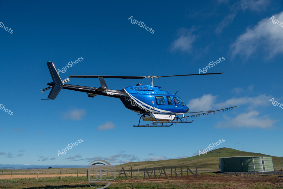
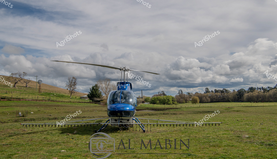
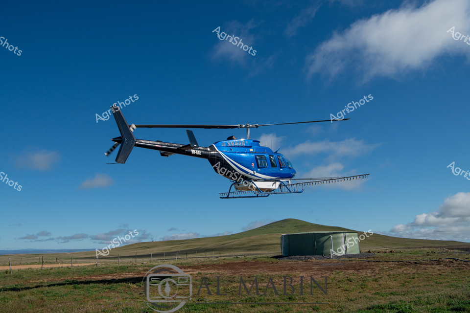
Agricultural aerial precision: A sleek blue and black Bell helicopter hovers low over a rural landscape, equipped with an extended spray boom for targeted crop treatment. The machinery demonstrates modern agricultural technology against a pristine azure sky with wispy clouds, capturing the expansive pastoral terrain of New South Wales. Careful positioning near a green water tank suggests strategic crop management, with the helicopter's specialized side-mounted spraying apparatus ready to deliver precise agricultural chemicals across farmland. The crisp, clean lines of the aircraft contrast beautifully with the soft undulating grasslands and distant rolling hills, representing the intersection of advanced farming techniques and natural agricultural environments. This image encapsulates the sophisticated approach to contemporary agricultural operations, where aerial technology enables farmers to maximize efficiency and crop protection with minimal ground disturbance. The professional-grade helicopter, meticulously maintained and strategically deployed, symbolizes the high-tech innovation driving Australian agricultural productivity.
 Image
Image
Brahman cattle surge across the rusty-red earth of Western Australia's Kimberley region, a thundering mass kicking up a billowing dust cloud that stretches across the arid landscape. A blue helicopter hovers overhead, guiding the herd with precision during the annual spring muster. The dense cluster of silvery-grey cattle moves as a single organism, their muscular bodies tightly packed and generating a swirling storm of ochre-colored dust against the stark landscape of scattered green scrubland and brilliant blue sky. Weathered timber fences and paddock boundaries define the edges of this dramatic agricultural scene, highlighting the vast scale of cattle operations in this remote part of Australia. The muster captures the raw energy and skill of pastoral work, with the helicopter pilot choreographing the movement of hundreds of heat-adapted Brahman cattle across the unforgiving terrain. This image epitomizes the rugged spirit of Australian cattle farming - a delicate dance of human technology, animal instinct, and harsh natural environment.
 Image
Image
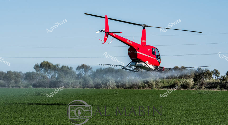
Cutting a vibrant crimson arc across the misty Riverina landscape, an agricultural helicopter sweeps low over lush green crops, executing precise aerial crop spraying. The Robinson R44 helicopter hovers just meters above the verdant field, its extended spray boom releasing a fine agricultural treatment with mechanical precision. Soft morning light filters through distant tree lines, creating a ethereal haze that softens the boundaries between sky and cultivated land. Powerful rotor blades generate a localized wind that ripples through the young crop, demonstrating the efficiency of modern agricultural technology in managing large-scale farming operations. The bright red helicopter stands in stark contrast to the muted green and grey tones of the rural environment, symbolizing the technological intervention in contemporary agricultural practices. This dynamic scene captures the intersection of advanced agricultural techniques and the timeless rhythms of crop cultivation in New South Wales' fertile Riverina region.
 Image
Image
Rugged Kimberley Helicopter Landing A sleek helicopter rests on the sun-baked rocky riverbed of a dramatic Western Australian landscape, its metallic body casting a sharp silhouette against the ancient geological formations. Massive red rock formations and layered cliff faces rise dramatically in the background, covered in sporadic green vegetation that clings tenaciously to the harsh terrain. The rocky riverscape stretches out in textured bands of ochre and rust-colored stone, with turbulent water threading between large stone boulders, revealing the raw, untamed character of a remote pastoral station. This scene captures the essential connection between modern agricultural mobility and the timeless wilderness of Western Australia's northern regions. The helicopter suggests rapid transport and survey capabilities critical to managing vast cattle stations and monitoring remote agricultural landscapes. The bright midday light emphasizes the stark beauty of the landscape, highlighting the rugged terrain that defines Australia's challenging agricultural frontier.
 Image
Image
Blue Robinson R22 helicopter perched dramatically on a rocky riverbank in the rugged Kimberley region of Western Australia, surrounded by ancient weathered limestone formations and lush tropical vegetation. The compact aircraft sits poised against a brilliant azure sky, highlighting the stark contrast between modern aviation technology and the timeless wilderness of northern Australia. Scattered boulders and a shallow meandering stream create a raw, untamed landscape that speaks to the challenging terrain of remote pastoral stations. Verdant pandanus palms and hardy shrubs frame the scene, suggesting the resilient ecosystems of this harsh yet beautiful landscape. The helicopter represents the critical mobility infrastructure for cattle stations and mineral exploration in this vast, isolated region, where ground transport is often impossible. The crisp blue of the aircraft gleams against the ochre rocks and deep green foliage, embodying the intersection of human enterprise and untouched natural environment that defines the Kimberley's unique character.
 Image
Image
Blue Robinson R44 helicopter rests on a weathered rocky riverbed in Western Australia's rugged Kimberley region. Layered sedimentary rock formations in warm ochre, rust, and tan hues create a dramatic geological backdrop, revealing millions of years of natural sculpting. The helicopter appears precisely positioned, suggesting a critical role in station management, aerial survey, cattle mustering, or remote area reconnaissance. Sparse native vegetation clings to the rocky terrain, highlighting the harsh yet resilient landscape of this expansive pastoral environment. Bright midday sunlight emphasizes the textural complexity of the rock surfaces, casting subtle shadows that accentuate the intricate geological stratification. This image captures the essential intersection of human technology and untamed Australian landscape, where precision machinery enables agricultural operations across immense, challenging terrain.
 Image
Image
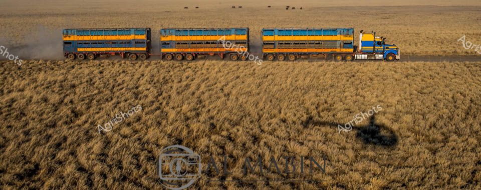
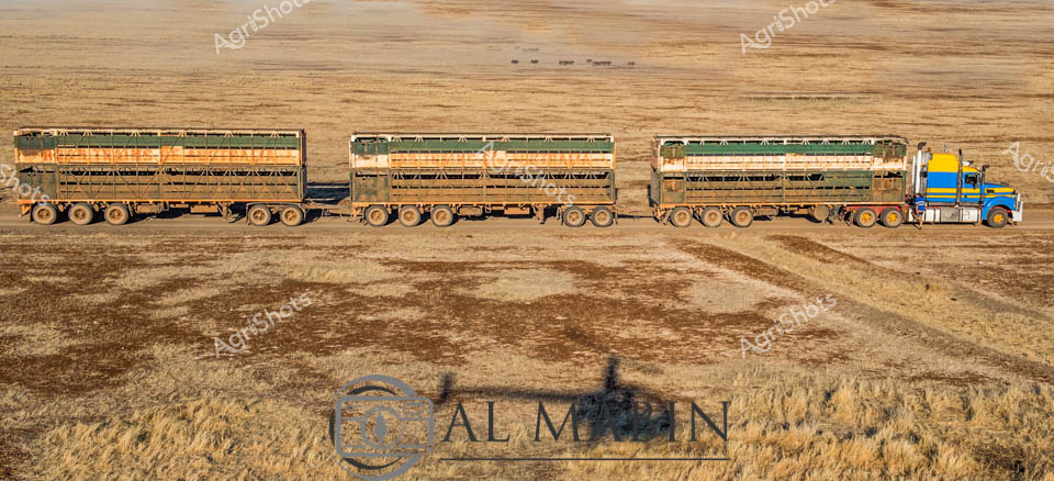
Sweeping across the golden wheat fields of Australia's vast interior, a massive road train rumbles through the harvest landscape, its blue and yellow triple-trailer configuration a testament to the nation's agricultural logistics. The heavy-duty truck navigates through rippling waves of mature grain, its powerful presence casting a stark shadow against the textured, sun-bleached paddock. In the distant background, a small herd of cattle grazes on the horizon, silhouetted against the warm, dusty atmosphere that defines the Northern Territory's agricultural heartland. The road train's robust design speaks to the demanding requirements of transporting livestock and produce across immense distances, with each trailer's sturdy construction built to withstand the challenging outback terrain. A helicopter's shadow hovers near the truck, suggesting aerial support or cattle mustering operations typical of large-scale Australian pastoral enterprises. The scene captures the raw essence of Australian agricultural infrastructure - rugged, efficient, and intrinsically connected to the expansive landscape that defines the continent's rural character.
 Image
Image
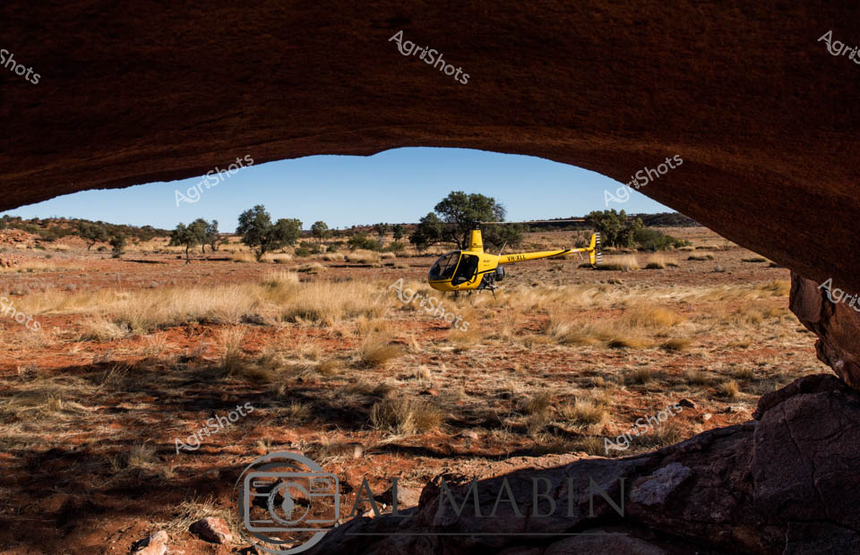
Scorching midday sunlight bathes the arid Central Queensland landscape, where a brilliant yellow helicopter hovers above the rust-colored earth and sparse golden spinifex grasses. Framed by a rocky overhang, the aircraft represents a critical tool in modern cattle station management, capturing the precision of aerial mustering techniques across vast, unforgiving terrain. Scattered eucalyptus trees punctuate the sparse desert-like environment, their muted green canopies providing minimal relief from the intense heat. The Robinson R44 helicopter, positioned strategically above the rocky ground, symbolizes the technological evolution of cattle ranching in Australia's remote interior, where traditional stockman methods blend with contemporary aerial reconnaissance and livestock movement strategies. Dusty, weathered ground textures reveal generations of pastoral history, with rocky outcrops and sparse vegetation highlighting the challenging agricultural conditions of this expansive Queensland station. The image captures the quintessential Australian rural narrative - human ingenuity and technological adaptation meeting the raw, uncompromising beauty of the continent's interior.
 Image
Image
Blue-bellied agricultural workhorse spreads precision agriculture across verdant pastureland. Gleaming azure Bell helicopter hovers low, equipped with an expansive spray boom delivering targeted agricultural treatments across rolling green paddocks. Dramatic cloudscapes billow across a softly overcast sky, casting muted light on the carefully maintained rural landscape dotted with sparse trees and fenced pastures. The sophisticated aerial application rig demonstrates modern farming's technological sophistication, using aerial precision to distribute crop treatments or fertilizers across challenging terrain. Industrial-grade agricultural engineering meets natural pastoral beauty, with the helicopter's metallic blue fuselage creating a striking visual contrast against the muted greens and grays of the New South Wales countryside. This image captures the intersection of high-tech agricultural methodology and timeless rural environments, showcasing how contemporary farmers leverage advanced equipment to manage and nurture agricultural landscapes.
 Video
Video
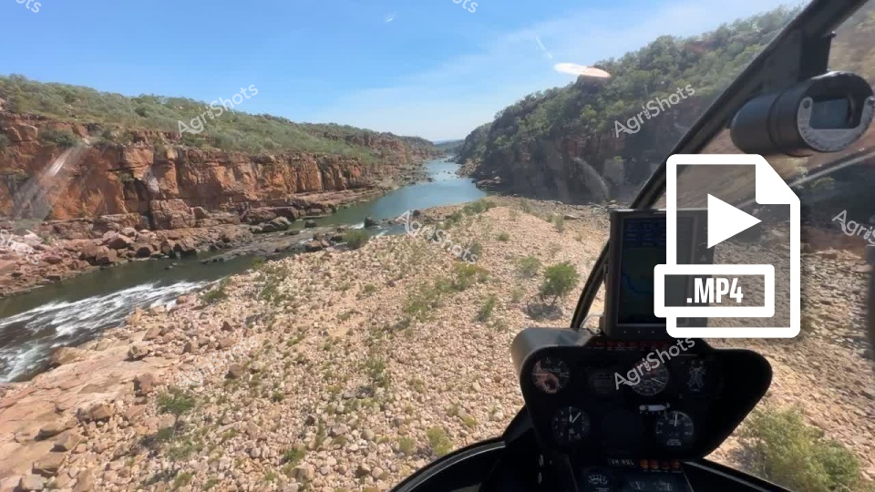
Cutting through the rugged Kimberley landscape, a helicopter navigates the dramatic gorge system of a remote Western Australian cattle station. Rust-red rocky cliffs rise sharply on either side of a winding river, creating a stunning natural corridor of ancient geological formations. Sparse vegetation clings to the rocky terrain, highlighting the harsh yet beautiful ecosystem of Australia's northwest. The helicopter's cockpit frame provides a pilot's-eye view of the extraordinary landscape, capturing the scale and wildness of station country. Smooth water flows between massive stone outcrops, reflecting the brilliant blue sky and revealing the intricate topography carved over millennia. This aerial perspective showcases the immense and untamed character of Western Australia's interior, where pastoral operations navigate challenging but breathtaking environmental conditions.
 Image
Image
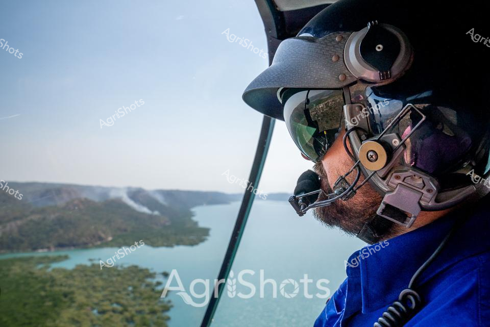
Aerial Reconnaissance over Kimberley Waterways A seasoned helicopter pilot surveys the vast inland waterways of Western Australia's Kimberley region, his weathered profile framed by high-tech navigation equipment and a robust blue flight suit. Intricate communication headsets and a specialized aviation helmet frame his bearded face as he navigates the aircraft above a stunning landscape of serpentine rivers and verdant flood plains. The expansive turquoise water below reflects the cloudless golden horizon, revealing the complex geographical tapestry of this remote agricultural frontier. His professional gaze tracks the meandering waterways, likely assessing land conditions, potential pastoral routes, or monitoring cattle station boundaries - a critical role in managing these immense agricultural territories. The close-up perspective captures the intense concentration of a pilot who knows these landscapes intimately, representing the sophisticated technological infrastructure that supports modern Australian agricultural operations. This image epitomizes the intersection of human expertise, advanced technology, and the raw, untamed beauty of Western Australia's agricultural heartland.
 Image
Image
Hovering amid the lush green eucalyptus woodland, a bright yellow and blue helicopter captures the essence of modern agricultural mustering in Western Australia. The compact Robinson R22 light helicopter provides precision aerial control, weaving between mature trees and navigating the rugged terrain of a remote station landscape. Sunlight filters through the dense foliage, casting dappled shadows on the rocky ground and highlighting the chopper's sleek profile against the verdant backdrop. This nimble aircraft represents the sophisticated technology enabling farmers and station managers to efficiently manage large herds across expansive and challenging pastoral terrain. The scene embodies the intersection of advanced aviation and traditional agricultural practices, showcasing how contemporary Australian farmers leverage innovative tools to work with the demanding environments of the continent's interior. The vibrant yellow and blue color scheme of the helicopter stands in striking contrast to the deep greens and earth tones of the surrounding bushland, symbolizing human ingenuity and adaptability in Australia's agricultural landscape.
 Image
Image
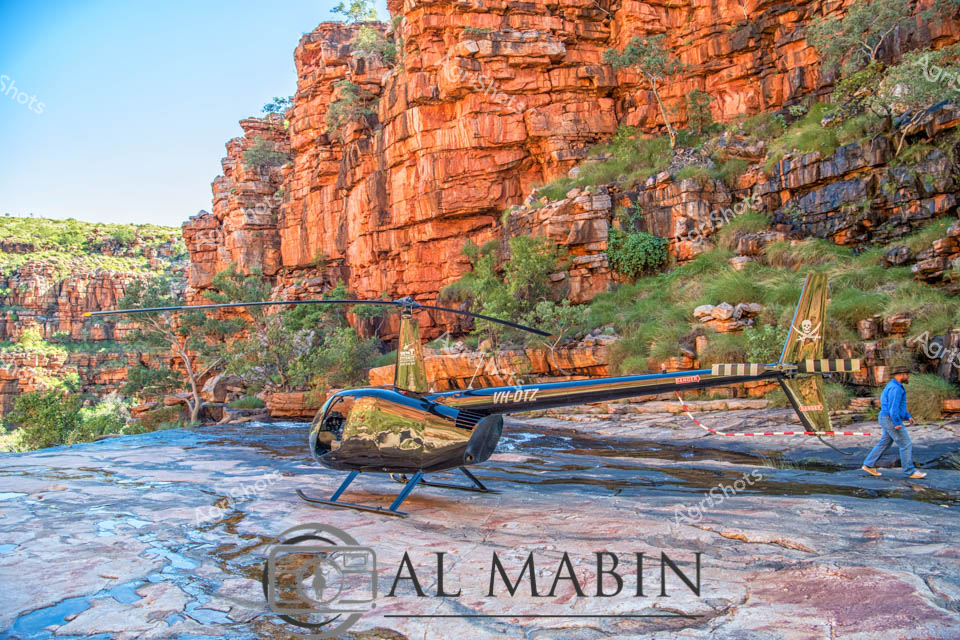
Nestled in the rugged Kimberley landscape, a compact Robinson R44 helicopter rests on the rocky riverbed of a dramatic gorge. Towering red sandstone cliffs rise vertically, their layered surfaces glowing with intense ochre and burnt sienna hues in the crisp morning light. The helicopter, gleaming in blue and olive tones, provides a striking contrast against the ancient geological formations and scattered green vegetation clinging to the rock faces. A lone figure in a blue work shirt walks near the aircraft, suggesting this is likely a station (ranch) reconnaissance or survey mission typical of agricultural and pastoral operations in remote Western Australian terrain. The rocky riverbed, wet and reflecting blue tones, indicates recent rainfall or seasonal water flow characteristic of the region's monsoonal climate. This image captures the intersection of modern aviation technology with the timeless, challenging landscape of Australia's northwestern frontier, highlighting the critical role of aerial transport in managing vast, isolated agricultural properties.
 Video
Video
The video footage captures a pristine, lush green agricultural landscape, showcasing an expansive field with a uniform, vibrant green texture that suggests a healthy, well-maintained crop or pasture. The verdant surface appears smooth and dense, with subtle variations in tone creating a rich, almost velvety visual effect that hints at potential agricultural use - perhaps a wheat field, a carefully managed grass paddock, or a meticulously cultivated agricultural plot. A .MOV video file icon positioned in the right corner of the frame suggests this is a digital video clip, likely part of an agricultural or farming documentary collection. The uniform green background creates a sense of tranquility and potential, representing the foundational essence of agricultural productivity - the fertile ground from which sustenance and livelihood emerge. The subtle light gradient across the green surface indicates potential early morning or late afternoon lighting, with a soft luminescence creating depth and dimension in the seemingly endless green expanse. This video clip appears primed to showcase the beauty of agricultural landscapes, highlighting the fundamental canvas upon which farming activities unfold. The pristine, unblemished green field represents possibility, growth, and the fundamental promise of agricultural endeavors - a visual testament to the nurturing potential of cultivated land.
 Image
Image
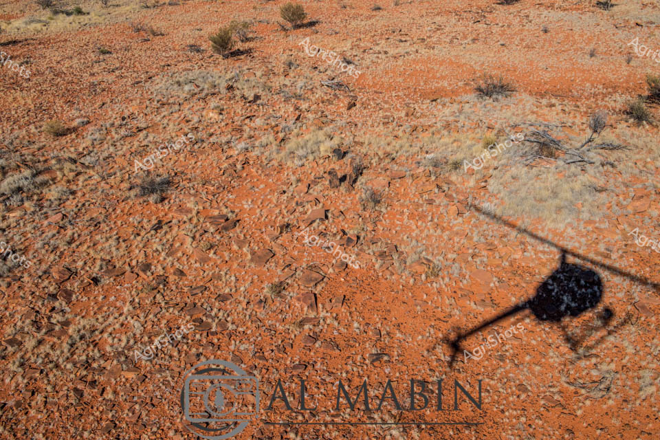
Burnt ochre earth stretches across the arid Queensland station landscape, a classic Central Australian pastoral terrain dotted with sparse saltbush and scattered rocky ground. A helicopter's elongated shadow cuts a stark silhouette against the rich terracotta soil, suggesting active cattle mustering operations in this remote agricultural setting. The rugged, stony ground tells a story of resilience - both of the landscape and the agricultural workers navigating this challenging environment. Hints of dried grasses and low scrub punctuate the rocky terrain, revealing the sparse vegetation typical of Australia's inland cattle stations. The deep orange and rust-colored ground speaks to decades of weathering, mineral-rich soil that supports extensive beef cattle operations across Queensland's vast pastoral zones. The AgShots watermark and carefully framed helicopter shadow underscore this as a professional agricultural documentation, capturing the essence of large-scale cattle station operations in Australia's challenging interior.
 Image
Image
Cattle Road Train across the Northern Territory's Dusty Pastoral Landscape A powerful road train stretches across the golden, sun-scorched grasslands of the Northern Territory, its three interconnected trailers designed for transporting livestock. The robust blue and yellow prime mover anchors this massive agricultural transport vehicle, its multi-tiered stock trailers constructed with sturdy metal frameworks and green protective side panels. Dust billows softly around the truck's wheels, suggesting the arduous journey through remote pastoral terrain typical of Australia's northern cattle country. The landscape is a tapestry of dried grasses and earth tones, reflecting the harsh yet beautiful environment of the region's cattle stations. This road train represents the critical infrastructure of Australia's beef industry, connecting vast cattle properties with processing facilities across thousands of kilometers of rugged outback. The scene captures the essence of modern agricultural logistics - a testament to the engineering and determination required to move livestock across some of the world's most challenging landscapes.
 Image
Image
Cutting a vivid red against the expansive green rice paddy, an agile Robinson R22 helicopter hovers low, executing precision agricultural spraying in the heart of the Riverina. Equipped with extended spray booms, the lightweight helicopter drifts mere meters above the lush irrigated field, delivering targeted crop treatment with exceptional maneuverability. The late morning light illuminates the verdant landscape, revealing a patchwork of meticulously cultivated agricultural terrain bordered by mature eucalyptus trees on the horizon. Sophisticated aerial agricultural techniques like these demonstrate the advanced technological approaches modern Australian farmers employ to optimize crop health and yield across challenging rural landscapes. The bright red helicopter represents a perfect fusion of technological innovation and agricultural expertise, showcasing how cutting-edge aviation supports sustainable farming practices in New South Wales. The crisp blue sky and uniform green field create a stark, beautiful backdrop that highlights the precision and skill of agricultural aviation.
 Video
Video
Golden dawn cascades across the Kimberley landscape, transforming a serpentine river into a liquid mirror reflecting an extraordinary altocumulus cloudscape. The pre-dawn light transforms the wilderness, rendering the sky in luminous bands of amber, gold, and deep slate grey, with clouds textured like rumpled silk against the horizon. Dense riverine vegetation frames the waterway, suggesting this is a remote location in Western Australia's northern station country, where ancient landscapes stretch uninterrupted toward distant horizons. The MP4 video icon suggests this breathtaking scene is captured as moving footage, likely shot from an aerial perspective that reveals the magnificent topographical complexity of the Australian interior. Soft morning light gradually illuminates the terrain, promising another scorching day in one of Australia's most challenging and beautiful agricultural environments. The image captures the raw, untamed essence of the Australian landscape - a testament to the dramatic natural beauty that underpins the nation's agricultural heritage.
 Image
Image
Cutting-edge agricultural surveillance unfolds against the ancient, layered rockscapes of Western Australia's rugged terrain. A sleek blue helicopter anchors one side of the frame, while a modern drone hovers dynamically in the foreground - twin technological sentinels capturing the expansive station landscape. The geological backdrop reveals intricate horizontal strata of ochre, rust, and tan-colored rock formations, punctuated by sparse green vegetation clinging to the rocky surfaces. AgriShots watermark suggests this is a professional documentation of contemporary farming technology, showcasing how aerial reconnaissance has revolutionized agricultural monitoring in challenging outback environments. The precision and mobility of these aerial platforms highlight the sophisticated technological approaches modern Australian agricultural operations employ to manage vast, remote landscapes. The golden light and textured rocky terrain create a striking contrast with the high-tech equipment, symbolizing the intersection of cutting-edge innovation and timeless natural terrain.
 Image
Image
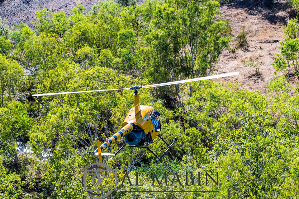
Yellow Eurocopter navigating the dense eucalyptus woodland of a remote Western Australian cattle station, hovering amidst vibrant lime-green foliage during cattle mustering operations. The precision-engineered aircraft, marked in bold yellow and blue, represents the modern intersection of agricultural technology and rugged pastoral landscape, suspended delicately above the undulating terrain. Aerial mustering techniques transform traditional livestock management, allowing rapid and efficient movement of cattle across vast, challenging landscapes where ground access remains difficult. The helicopter's strategic positioning demonstrates the skill of the pilot in manoeuvring through challenging tree-lined country, embodying the sophisticated approach to large-scale agricultural management in Western Australia's expansive pastoral zones. Sunlight filters through the tree canopy, creating a dynamic interplay of light and shadow that highlights the technical capabilities of contemporary agricultural aviation. The scene captures the essence of Australian agricultural innovation - blending advanced machinery with untamed natural environments to sustain livestock production across thousands of square kilometres.
 Video
Video
A compact helicopter rests on a rugged outback terrain, positioned on a rocky red soil landscape typical of central Australia. Sparse native grasses and slender eucalyptus trees frame the scene against a pristine azure sky with a single wispy cloud. The aircraft appears to be a small, sleek model, potentially used for agricultural survey, livestock management, or aerial crop monitoring in remote rural regions. Reddish-brown stones and gravel dominate the foreground, creating a textured surface that highlights the harsh, arid environmental conditions of the Australian interior. The .MOV file tag suggests this is a video capture documenting agricultural or reconnaissance operations in a challenging landscape where aerial transportation provides critical mobility across vast, challenging terrains.
 Image
Image
Robinson R44 helicopter rests on the rugged rocky riverbed of a remote Kimberley landscape in Western Australia. Dramatic rust-red escarpments rise sharply behind the aircraft, creating a striking geological backdrop of layered sandstone cliffs covered in sparse tropical vegetation. The helicopter appears precisely positioned amid textured limestone shelves, with tufts of spinifex grass emerging between weathered stone platforms and shallow water pools. This scene captures the raw, unforgiving beauty of Australia's northwestern frontier - a landscape that demands specialized aerial transport for station management, geological surveys, and cattle mustering operations. The blue and black helicopter represents a critical mobility asset in this isolated terrain, where ground transportation can be challenging and time-consuming. The brilliant clear sky and harsh midday light emphasize the uncompromising environmental conditions of this remarkable station country, highlighting the technological adaptation required to navigate and work within such a demanding agricultural frontier.
 Image
Image
Agricultural aerial spraying sweeps across the open pastoral landscape, capturing the precision and technological advancement of modern broadacre farming. A sleek blue and black Bell helicopter hovers low over the undulating grasslands, its extended spray boom delivering targeted agricultural treatments with surgical accuracy. The expansive sky of deep azure blue provides a dramatic backdrop, punctuated by soft white clouds drifting above the rugged rural terrain. A weathered green metal farm shed sits anchored in the foreground, grounding the scene in the practical realities of agricultural infrastructure. The helicopter represents a sophisticated approach to crop and pasture management, demonstrating how advanced machinery can efficiently cover vast agricultural spaces with minimal ground disturbance. This image encapsulates the technological innovation driving Australian agricultural practices, where aerial techniques allow farmers to manage expansive properties with remarkable efficiency and minimal environmental impact.
 Image
Image
Aerial reconnaissance captures the dramatic landscapes of Western Australia's remote river systems, revealing the rugged beauty of a pastoral station from a helicopter's vantage point. A sinuous waterway cuts through steep, rocky escarpments, its muddy waters flanked by resilient vegetation clinging to the harsh terrain. The navigation display glows with topographical details, while instrument panels hint at the precision required to navigate this challenging environment. Weathered cliff faces in russet and ochre tones rise sharply from the riverbanks, creating a corridor of natural grandeur that speaks to the untamed spirit of the Australian outback. Sparse trees and shrubs punctuate the rocky slopes, demonstrating the tenacious ecosystem of this arid region. The clear blue sky and expansive landscape showcase the immense scale and isolation characteristic of Western Australia's inland stations, where water resources are critical to pastoral operations.
 Image
Image
Rugged sandstone cliffs rise dramatically on either side of a flowing river in the heart of Western Australia's Kimberley region. Cool blue water weaves between weathered rock formations, creating a network of smooth stone channels and small cascades. A helicopter hovers in the middle distance, suggesting the vast scale of this remote pastoral landscape and hinting at the critical role of aerial transport in managing extensive cattle stations. Rich ochre-colored rock walls contrast brilliantly with the deep blue sky and green vegetation clinging to the rocky terrain, capturing the raw, untamed beauty of Australia's northwestern wilderness. Ancient geological layers tell a story of millions of years of erosion, with each rock face revealing intricate textures and subtle color variations from rust-red to soft tan. This landscape epitomizes the challenging yet breathtaking environment of Western Australian pastoral country, where resilience and adaptation are key to survival.
 Image
Image
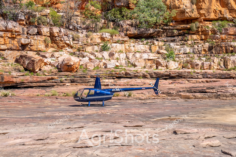
Perched on the sun-baked rocky banks of a rugged Kimberley river, a sleek blue Robinson R44 helicopter rests against a backdrop of ancient sandstone escarpments and lush green vegetation. A photographer in a pink shirt and wide-brimmed agricultural hat stands nearby, capturing the dramatic landscape through her lens. The rocky foreground reveals intricate textures of weathered stone, telling stories of millennia of geological transformation. Vibrant blue skies and the rugged terrain showcase the raw beauty of Western Australia's remote station country, where aviation plays a crucial role in monitoring and managing vast pastoral landscapes. The helicopter's registration VH-HUL gleams against the natural palette, symbolizing the modern intersection of technology and traditional agricultural practices. This scene epitomizes the spirit of Australian agricultural exploration - combining cutting-edge mobility with an intimate connection to the land's timeless terrain.
 Image
Image
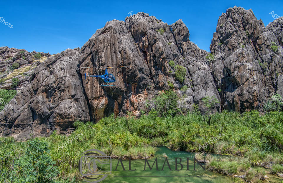
Rugged geological formations of weathered grey and rust-colored granite thrust skyward in the remote Kimberley region of Western Australia, creating a dramatic backdrop for an azure blue helicopter hovering near the rocky escarpment. A verdant green waterway winds through lush sedge grasses and tropical vegetation, representing the lifeline of this harsh yet breathtaking landscape. The strategic positioning of the helicopter suggests aerial survey work, potentially related to pastoral station management, geological exploration, or wildlife conservation efforts characteristic of this vast northern Australian territory. Brilliant cobalt blue sky frames the scene, emphasizing the stark contrast between the ancient, fractured rock formations and the modern technological intervention of the aircraft. The landscape epitomizes the challenging yet magnificent environment of Western Australia's agricultural frontier, where pastoral stations cover immense territories requiring sophisticated aerial monitoring and management techniques. This image captures the intersection of rugged natural wilderness and contemporary agricultural practice, revealing the sophisticated technological approaches required to sustainably manage Australia's most remote agricultural regions.
 Video
Video
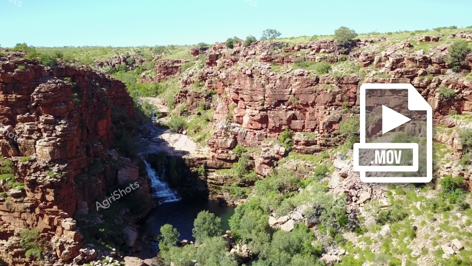
This stunning video footage captures a breathtaking Australian landscape featuring a dramatic rocky gorge with cascading waterfall in an arid region. The clip showcases rugged red sandstone cliffs with layered geological formations, creating a stunning natural canyon environment with rich terracotta and rust-colored rock walls. Lush green vegetation punctuates the rocky terrain, with small trees and shrubs growing between the rocky outcrops, suggesting this is likely a scene from the North West region of Western Australia or the Northern Territory. A beautiful waterfall tumbles down the rocky cliff face, creating a striking contrast between the hard stone surfaces and the fluid, dynamic water movement. The video scene appears to be captured during a dry season, with bright, clear sunlight illuminating the landscape and highlighting the textural details of the rock formations. The waterfall creates a small pool at its base, surrounded by boulders and vegetation, indicating this is likely a permanent water source in an otherwise harsh landscape. The clip provides a stunning visual representation of Australia's rugged interior landscapes, showcasing the dramatic geological formations and resilient ecosystems that characterize the continent's remote regions. The combination of stark rock walls, vibrant vegetation, and flowing water creates a powerful and mesmerizing scene that captures the raw beauty of the Australian wilderness.
 Image
Image
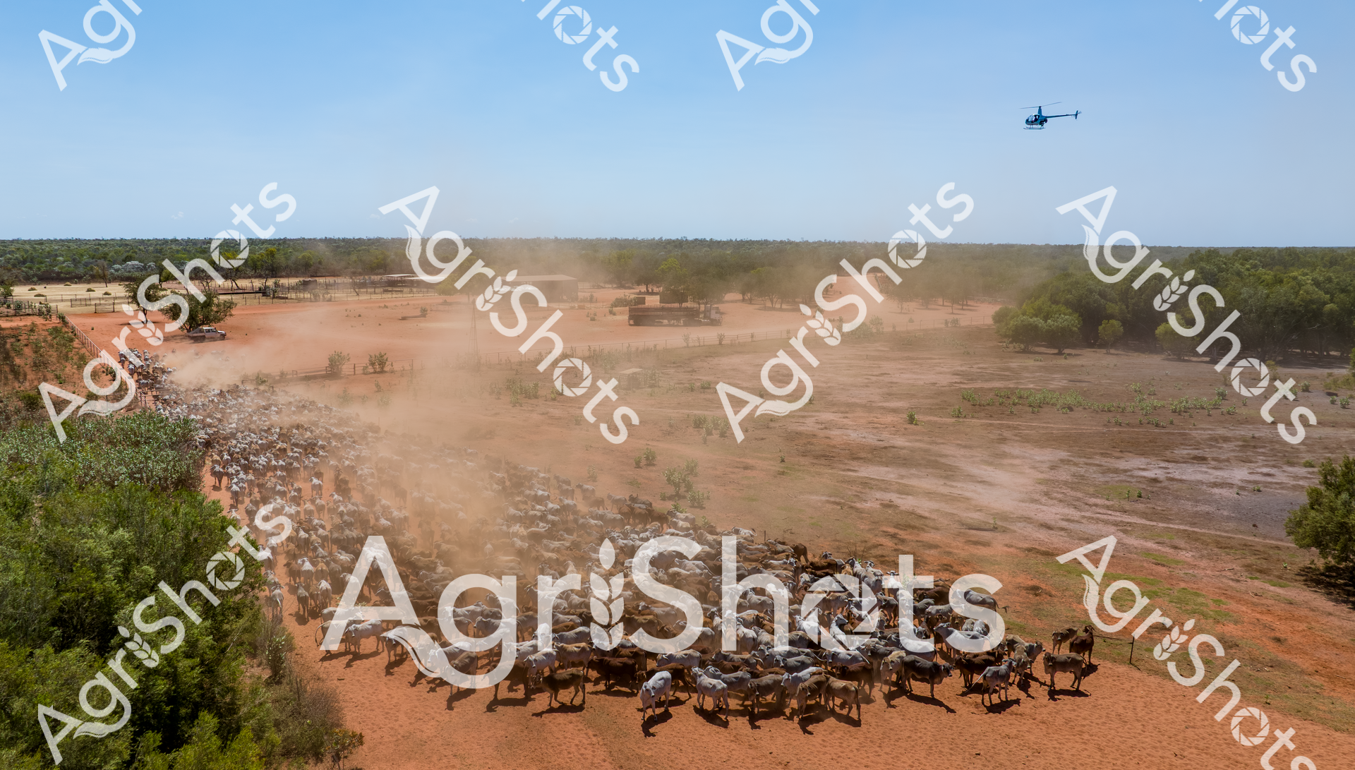
Dust billows across the burnt-orange landscape as a vibrant cattle muster unfolds in Western Australia's rugged Kimberley region. A tightly packed herd of distinctive Brahman cattle, with their characteristic humped shoulders and loose, silvery-grey skin, moves purposefully across the dry, sandy terrain. A white utility vehicle tracks alongside the herd, while a helicopter hovers overhead, guiding the animals with precision and strategic movement. The stark landscape tells a story of resilience - scattered low scrub and sparse vegetation frame the scene, highlighting the challenging environment of this remote agricultural frontier. The early spring light casts a warm, clear illumination across the landscape, capturing the dynamic energy of pastoral work that has been central to Australia's agricultural heritage for generations. This aerial perspective beautifully illustrates the intricate choreography of modern cattle mustering, where traditional skills meet contemporary agricultural technology.
 Image
Image
Agricultural aviation in action: a vibrant red and blue helicopter hovers low over a lush green rice paddy, its extended spray boom releasing a fine mist of agricultural treatment across the carefully cultivated field. The morning light bathes the Riverina landscape in soft golden tones, highlighting the precision of modern farming techniques against the expansive, meticulously leveled agricultural terrain. A crisp irrigation channel runs parallel to the field, defining the boundary between cultivated land and natural landscape, while the helicopter demonstrates the sophisticated aerial application methods used in contemporary rice production. The dust and spray create a ethereal haze around the aircraft, capturing the dynamic intersection of technology and agriculture in New South Wales. Rolling green crops stretch to the horizon, punctuated by the rhythmic movement of the helicopter, symbolizing the innovative approaches Australian farmers employ to maximize crop health and yield. The scene epitomizes the cutting-edge agricultural practices of the Riverina region, where advanced machinery and strategic land management come together to sustain agricultural productivity.
 Video
Video
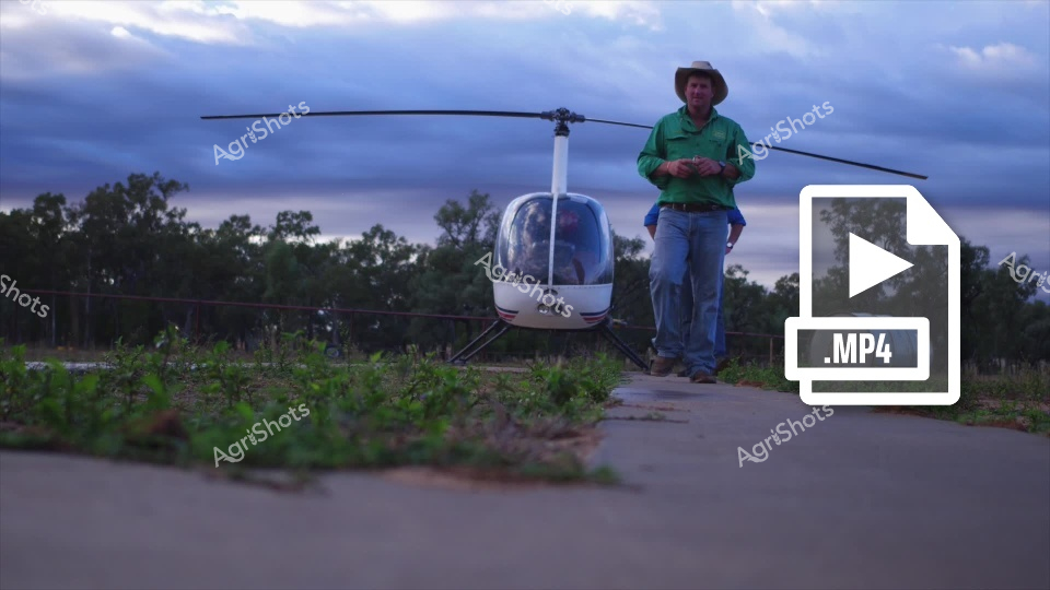
A compact Robinson R22 helicopter rests on a concrete pad, set against a moody twilight sky with deep blue-grey clouds. A farmer in a green collared shirt and wide-brimmed hat stands confidently beside the aircraft, surveying the surrounding rural landscape of scrub trees and low vegetation. The sleek white helicopter's rotor blades extend prominently, suggesting agricultural survey or inspection work typical of modern farming operations. Soft evening light bathes the scene, casting subtle shadows across the ground and highlighting the connection between advanced technology and traditional agricultural practices. The MP4 video icon suggests this is part of a dynamic agricultural documentation series capturing innovative farming techniques and aerial landscape assessment.
 Image
Image
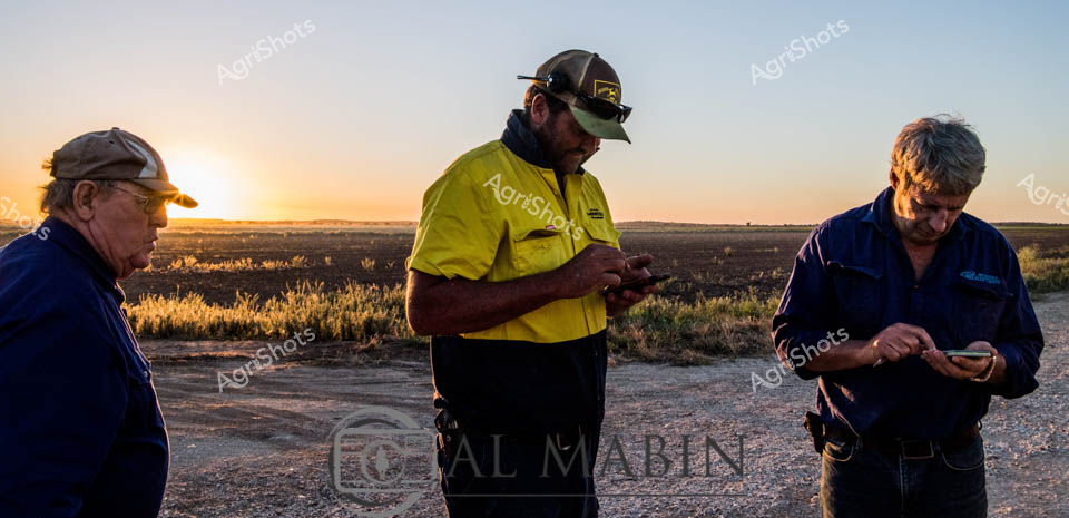
Rural dawn breaks over the Riverina's expansive agricultural landscape, casting golden light across a burnt-orange terrain where three agricultural workers pause on a dusty track. Dressed in deep navy and high-visibility yellow workwear, they are intently focused on mobile devices, likely coordinating complex irrigation or crop management strategies for the surrounding fields. The worker in the bright yellow shirt stands centrally, backlit by the rising sun, which illuminates the textured grasses and creates a dramatic silhouette against the wide-open horizon. Agricultural technology meets traditional farming practice in this moment - seasoned workers using digital tools to monitor and manage the intricate systems of modern farming. Their postures and concentration suggest a collaborative approach, each engaged with their device yet connected to a shared purpose of agricultural productivity. The soft morning light and open landscape evoke the quiet determination of rural workers beginning their day, bridging generations of farming knowledge with contemporary digital innovation.
 Image
Image
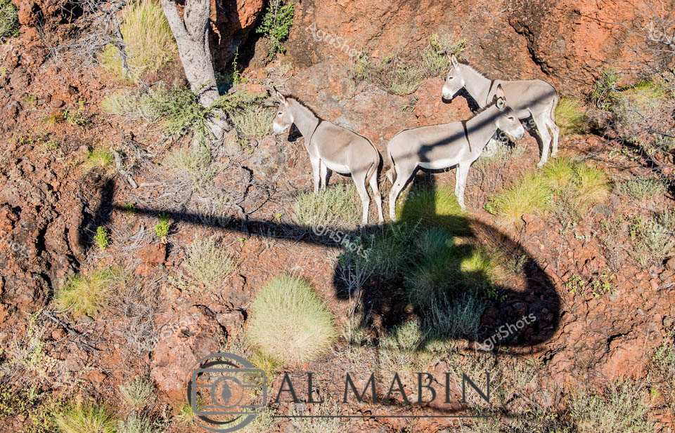
Wild African donkeys traverse a rugged rocky landscape, casting long shadows across sun-baked earth studded with sparse tufts of sage-green grasses. Four pale grey donkeys stand alert among weathered rust-colored stone formations, their lean bodies blending seamlessly with the arid terrain. The harsh, unforgiving landscape speaks of extreme conditions where only the most resilient creatures survive, with sparse vegetation and jagged rock surfaces creating a textural backdrop of survival and endurance. Delicate shadows stretch across the ground, highlighting the animals' muscular silhouettes and the intricate topography of their desert home. The Al Mabin watermark suggests this powerful image captures the raw essence of wilderness photography, documenting the understated beauty of donkeys in their natural habitat. The scene evokes a sense of quiet strength and adaptation, where these hardy animals navigate a landscape that demands resilience and resourcefulness.
 Image
Image
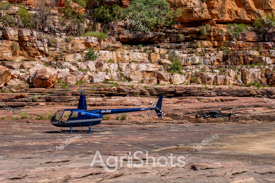
Remote Kimberley Helicopter Survey: A sleek blue Robinson R44 helicopter rests on the rugged rocky terrain of a West Australian river system, surrounded by dramatic layered sandstone cliffs in rich ochre and rust tones. The landscape reveals ancient geological formations with stratified rock surfaces, sparse native grasses, and scattered vegetation clinging to the rocky outcrops. This aerial reconnaissance scene captures the expansive and challenging landscape of a pastoral station, where helicopters are critical for surveying vast agricultural properties, monitoring livestock, and assessing land conditions across thousands of remote hectares. A small drone sits nearby, suggesting advanced technological support for comprehensive landscape mapping and agricultural management. The harsh, sculptural terrain speaks to the resilience required in Australian agricultural operations, where modern aviation technology meets timeless geological landscapes. The crisp blue of the helicopter provides a striking contrast against the warm earth tones, symbolizing human innovation navigating through some of the continent's most unforgiving yet breathtaking environments.
Well, you've ploughed through the whole field!
No more crops to harvest here, mate.
Try searching for something else in our library of 50,000+ royalty-free media: